You are here: Home > Network List > TA - USArray Transportable Network (new EarthScope stations) Stations List
> Station V24A Rampart Ranch, Las Vegas, NM, USA > Earthquake Result Viewer
V24A Rampart Ranch, Las Vegas, NM, USA - Earthquake Result Viewer
| Earthquake location: |
Southeast Of Loyalty Islands |
| Earthquake latitude/longitude: |
-22.4/171.3 |
| Earthquake time(UTC): |
2008/11/23 (328) 08:58:18 GMT |
| Earthquake Depth: |
40 km |
| Earthquake Magnitude: |
5.6 MW, 5.3 MS, 5.3 MB, 5.5 MW |
| Earthquake Catalog/Contributor: |
WHDF/NEIC |
|
| Network: |
TA USArray Transportable Network (new EarthScope stations) |
| Station: |
V24A Rampart Ranch, Las Vegas, NM, USA |
| Lat/Lon: |
35.73 N/105.27 W |
| Elevation: |
2187 m |
|
| Distance: |
97.7 deg |
| Az: |
54.653 deg |
| Baz: |
248.045 deg |
| Ray Param: |
0.040110495 |
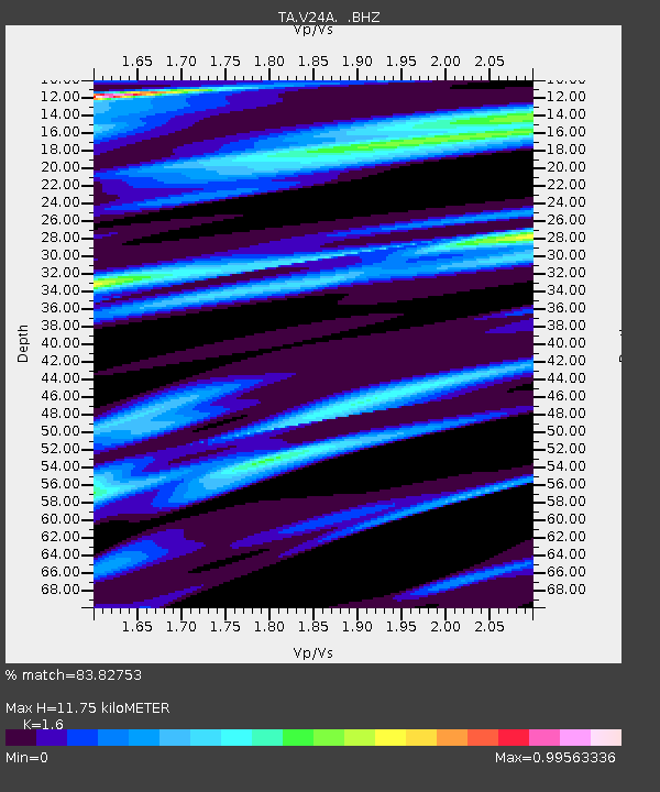
| Estimated Moho Depth: |
11.75 km |
| Estimated Crust Vp/Vs: |
1.60 |
| Assumed Crust Vp: |
6.419 km/s |
| Estimated Crust Vs: |
4.012 km/s |
| Estimated Crust Poisson's Ratio: |
0.18 |
|
| Radial Match: |
83.82753 % |
| Radial Bump: |
320 |
| Transverse Match: |
62.383385 % |
| Transverse Bump: |
353 |
| SOD ConfigId: |
2658 |
| Insert Time: |
2010-03-06 23:46:45.335 +0000 |
| GWidth: |
2.5 |
| Max Bumps: |
400 |
| Tol: |
0.001 |
|

Signal To Noise
| Channel | StoN | STA | LTA |
| TA:V24A: :BHZ:20081123T09:11:17.299014Z | 1.9397439 | 4.819901E-7 | 2.4848134E-7 |
| TA:V24A: :BHN:20081123T09:11:17.299014Z | 2.919881 | 5.882989E-7 | 2.0148043E-7 |
| TA:V24A: :BHE:20081123T09:11:17.299014Z | 0.29506657 | 6.539834E-8 | 2.2163928E-7 |
| Arrivals |
| Ps | 1.1 SECOND |
| PpPs | 4.7 SECOND |
| PsPs/PpSs | 5.8 SECOND |


