You are here: Home > Network List > UU - University of Utah Regional Network Stations List
> Station KNB Kanab, UT, USA > Earthquake Result Viewer
KNB Kanab, UT, USA - Earthquake Result Viewer
| Earthquake location: |
Kermadec Islands, New Zealand |
| Earthquake latitude/longitude: |
-30.8/-178.1 |
| Earthquake time(UTC): |
2019/06/15 (166) 22:55:02 GMT |
| Earthquake Depth: |
35 km |
| Earthquake Magnitude: |
7.4 Mwp |
| Earthquake Catalog/Contributor: |
NEIC PDE/us |
|
| Network: |
UU University of Utah Regional Network |
| Station: |
KNB Kanab, UT, USA |
| Lat/Lon: |
37.02 N/112.82 W |
| Elevation: |
1715 m |
|
| Distance: |
91.0 deg |
| Az: |
46.637 deg |
| Baz: |
231.392 deg |
| Ray Param: |
0.041629385 |
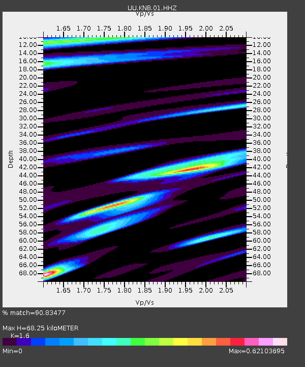
| Estimated Moho Depth: |
68.25 km |
| Estimated Crust Vp/Vs: |
1.60 |
| Assumed Crust Vp: |
6.194 km/s |
| Estimated Crust Vs: |
3.871 km/s |
| Estimated Crust Poisson's Ratio: |
0.18 |
|
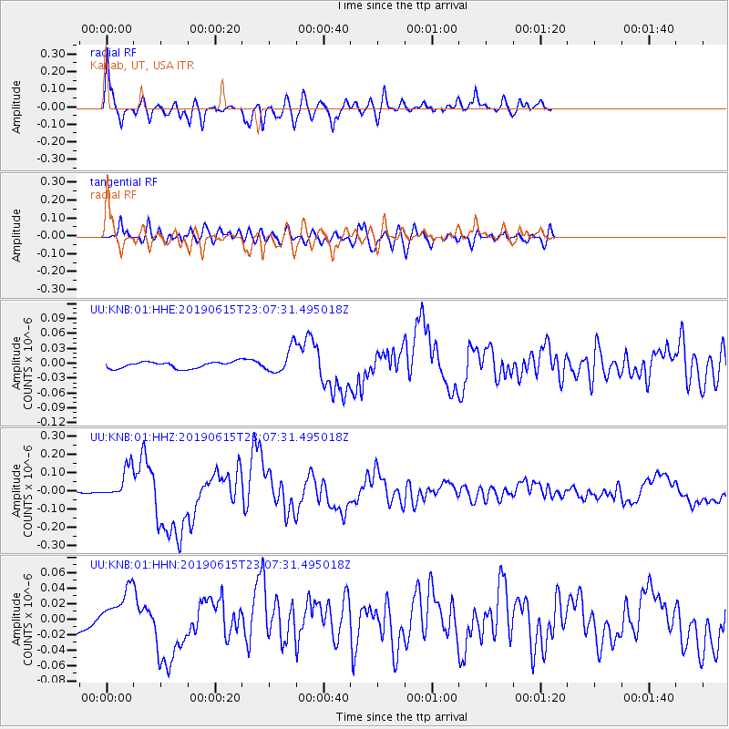
| Radial Match: |
90.83477 % |
| Radial Bump: |
400 |
| Transverse Match: |
68.525764 % |
| Transverse Bump: |
400 |
| SOD ConfigId: |
18369291 |
| Insert Time: |
2019-06-29 23:10:09.155 +0000 |
| GWidth: |
2.5 |
| Max Bumps: |
400 |
| Tol: |
0.001 |
|
Signal To Noise
| Channel | StoN | STA | LTA |
| UU:KNB:01:HHZ:20190615T23:07:31.495018Z | 9.272468 | 8.960695E-8 | 9.663765E-9 |
| UU:KNB:01:HHN:20190615T23:07:31.495018Z | 2.3987312 | 2.7658846E-8 | 1.1530616E-8 |
| UU:KNB:01:HHE:20190615T23:07:31.495018Z | 3.8398275 | 2.5153128E-8 | 6.550588E-9 |
| Arrivals |
| Ps | 6.8 SECOND |
| PpPs | 28 SECOND |
| PsPs/PpSs | 35 SECOND |


