You are here: Home > Network List > UW - Pacific Northwest Regional Seismic Network Stations List
> Station KREP White Salmon, WA, USA > Earthquake Result Viewer
KREP White Salmon, WA, USA - Earthquake Result Viewer
| Earthquake location: |
Kermadec Islands, New Zealand |
| Earthquake latitude/longitude: |
-30.8/-178.1 |
| Earthquake time(UTC): |
2019/06/15 (166) 22:55:02 GMT |
| Earthquake Depth: |
35 km |
| Earthquake Magnitude: |
7.4 Mwp |
| Earthquake Catalog/Contributor: |
NEIC PDE/us |
|
| Network: |
UW Pacific Northwest Regional Seismic Network |
| Station: |
KREP White Salmon, WA, USA |
| Lat/Lon: |
45.89 N/121.46 W |
| Elevation: |
472 m |
|
| Distance: |
92.0 deg |
| Az: |
35.704 deg |
| Baz: |
225.955 deg |
| Ray Param: |
0.041522034 |
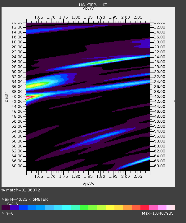
| Estimated Moho Depth: |
40.25 km |
| Estimated Crust Vp/Vs: |
1.60 |
| Assumed Crust Vp: |
6.597 km/s |
| Estimated Crust Vs: |
4.123 km/s |
| Estimated Crust Poisson's Ratio: |
0.18 |
|
| Radial Match: |
81.86372 % |
| Radial Bump: |
379 |
| Transverse Match: |
76.31138 % |
| Transverse Bump: |
400 |
| SOD ConfigId: |
18369291 |
| Insert Time: |
2019-06-29 23:10:28.628 +0000 |
| GWidth: |
2.5 |
| Max Bumps: |
400 |
| Tol: |
0.001 |
|

Signal To Noise
| Channel | StoN | STA | LTA |
| UW:KREP: :HHZ:20190615T23:07:35.930016Z | 4.337921 | 3.5922544E-6 | 8.2810504E-7 |
| UW:KREP: :HHN:20190615T23:07:35.930016Z | 2.1318088 | 7.48387E-7 | 3.5105728E-7 |
| UW:KREP: :HHE:20190615T23:07:35.930016Z | 1.0536655 | 5.43122E-7 | 5.154596E-7 |
| Arrivals |
| Ps | 3.7 SECOND |
| PpPs | 15 SECOND |
| PsPs/PpSs | 19 SECOND |


