You are here: Home > Network List > TA - USArray Transportable Network (new EarthScope stations) Stations List
> Station V24A Rampart Ranch, Las Vegas, NM, USA > Earthquake Result Viewer
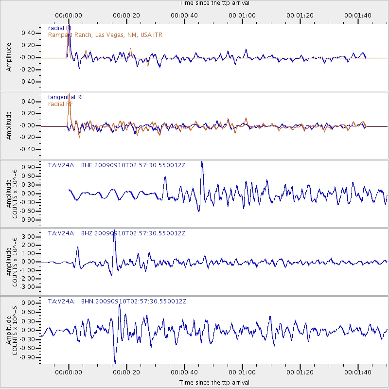
V24A Rampart Ranch, Las Vegas, NM, USA - Earthquake Result Viewer

| Earthquake location: |
Kuril Islands |
| Earthquake latitude/longitude: |
48.3/154.2 |
| Earthquake time(UTC): |
2009/09/10 (253) 02:46:50 GMT |
| Earthquake Depth: |
36 km |
| Earthquake Magnitude: |
6.0 MB, 5.5 MS, 6.0 MW, 5.8 MW |
| Earthquake Catalog/Contributor: |
WHDF/NEIC |
|
| Network: |
TA USArray Transportable Network (new EarthScope stations) |
| Station: |
V24A Rampart Ranch, Las Vegas, NM, USA |
| Lat/Lon: |
35.73 N/105.27 W |
| Elevation: |
2187 m |
|
| Distance: |
70.5 deg |
| Az: |
58.054 deg |
| Baz: |
315.885 deg |
| Ray Param: |
0.054873753 |
| Estimated Moho Depth: |
42.25 km |
| Estimated Crust Vp/Vs: |
1.85 |
| Assumed Crust Vp: |
6.419 km/s |
| Estimated Crust Vs: |
3.479 km/s |
| Estimated Crust Poisson's Ratio: |
0.29 |
|
| Radial Match: |
83.45286 % |
| Radial Bump: |
343 |
| Transverse Match: |
83.67794 % |
| Transverse Bump: |
400 |
| SOD ConfigId: |
2622 |
| Insert Time: |
2010-03-06 23:47:05.561 +0000 |
| GWidth: |
2.5 |
| Max Bumps: |
400 |
| Tol: |
0.001 |
|
Signal To Noise
| Channel | StoN | STA | LTA |
| TA:V24A: :BHZ:20090910T02:57:30.550012Z | 7.9524407 | 6.639805E-7 | 8.349392E-8 |
| TA:V24A: :BHN:20090910T02:57:30.550012Z | 1.2306486 | 1.5986852E-7 | 1.299059E-7 |
| TA:V24A: :BHE:20090910T02:57:30.550012Z | 2.4040818 | 2.34484E-7 | 9.753578E-8 |
| Arrivals |
| Ps | 5.8 SECOND |
| PpPs | 18 SECOND |
| PsPs/PpSs | 24 SECOND |


