You are here: Home > Network List > TA - USArray Transportable Network (new EarthScope stations) Stations List
> Station V24A Rampart Ranch, Las Vegas, NM, USA > Earthquake Result Viewer
V24A Rampart Ranch, Las Vegas, NM, USA - Earthquake Result Viewer

| Earthquake location: |
Santa Cruz Islands |
| Earthquake latitude/longitude: |
-12.4/166.1 |
| Earthquake time(UTC): |
2009/10/07 (280) 22:50:15 GMT |
| Earthquake Depth: |
21 km |
| Earthquake Magnitude: |
5.8 MB |
| Earthquake Catalog/Contributor: |
WHDF/NEIC |
|
| Network: |
TA USArray Transportable Network (new EarthScope stations) |
| Station: |
V24A Rampart Ranch, Las Vegas, NM, USA |
| Lat/Lon: |
35.73 N/105.27 W |
| Elevation: |
2187 m |
|
| Distance: |
96.0 deg |
| Az: |
54.883 deg |
| Baz: |
259.166 deg |
| Ray Param: |
0.04061787 |
| Estimated Moho Depth: |
10.75 km |
| Estimated Crust Vp/Vs: |
1.60 |
| Assumed Crust Vp: |
6.419 km/s |
| Estimated Crust Vs: |
4.012 km/s |
| Estimated Crust Poisson's Ratio: |
0.18 |
|
| Radial Match: |
90.54147 % |
| Radial Bump: |
346 |
| Transverse Match: |
62.06741 % |
| Transverse Bump: |
251 |
| SOD ConfigId: |
2622 |
| Insert Time: |
2010-03-06 23:47:12.027 +0000 |
| GWidth: |
2.5 |
| Max Bumps: |
400 |
| Tol: |
0.001 |
|
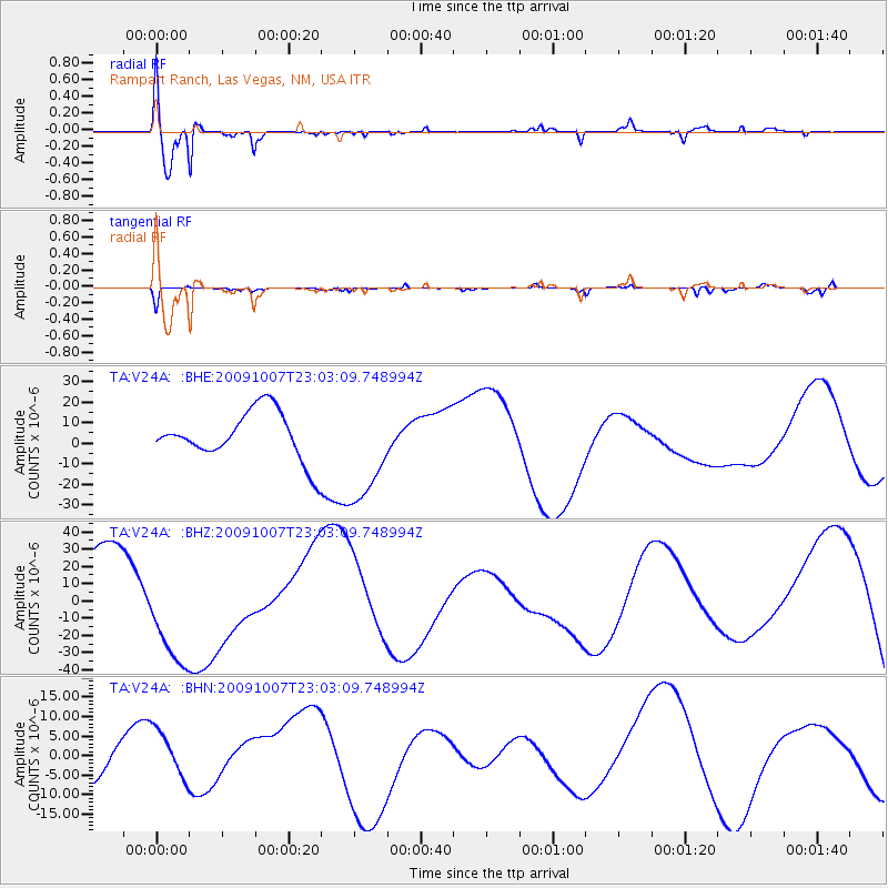
Signal To Noise
| Channel | StoN | STA | LTA |
| TA:V24A: :BHZ:20091007T23:03:09.748994Z | 1.7255521 | 3.2077787E-5 | 1.8589868E-5 |
| TA:V24A: :BHN:20091007T23:03:09.748994Z | 1.2558372 | 6.6941057E-6 | 5.330393E-6 |
| TA:V24A: :BHE:20091007T23:03:09.748994Z | 2.217214 | 2.5998757E-5 | 1.1725867E-5 |
| Arrivals |
| Ps | 1.0 SECOND |
| PpPs | 4.3 SECOND |
| PsPs/PpSs | 5.3 SECOND |


