You are here: Home > Network List > US - United States National Seismic Network Stations List
> Station CBKS Cedar Bluff, Kansas, USA > Earthquake Result Viewer
CBKS Cedar Bluff, Kansas, USA - Earthquake Result Viewer

| Earthquake location: |
San Juan Province, Argentina |
| Earthquake latitude/longitude: |
-31.6/-68.8 |
| Earthquake time(UTC): |
2016/11/20 (325) 20:57:43 GMT |
| Earthquake Depth: |
116 km |
| Earthquake Magnitude: |
6.4 MWP, 6.5 MWB |
| Earthquake Catalog/Contributor: |
NEIC PDE/NEIC COMCAT |
|
| Network: |
US United States National Seismic Network |
| Station: |
CBKS Cedar Bluff, Kansas, USA |
| Lat/Lon: |
38.81 N/99.74 W |
| Elevation: |
677 m |
|
| Distance: |
75.8 deg |
| Az: |
335.498 deg |
| Baz: |
153.078 deg |
| Ray Param: |
0.051149677 |
| Estimated Moho Depth: |
45.0 km |
| Estimated Crust Vp/Vs: |
1.80 |
| Assumed Crust Vp: |
6.483 km/s |
| Estimated Crust Vs: |
3.611 km/s |
| Estimated Crust Poisson's Ratio: |
0.27 |
|
| Radial Match: |
95.94961 % |
| Radial Bump: |
349 |
| Transverse Match: |
91.39081 % |
| Transverse Bump: |
400 |
| SOD ConfigId: |
1858631 |
| Insert Time: |
2016-12-04 21:04:23.889 +0000 |
| GWidth: |
2.5 |
| Max Bumps: |
400 |
| Tol: |
0.001 |
|
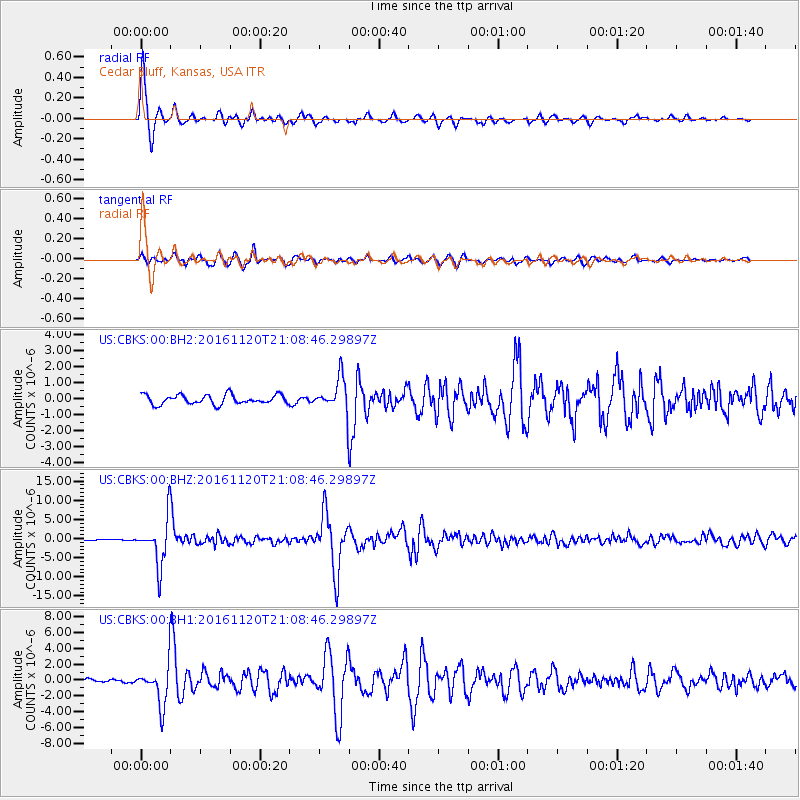
Signal To Noise
| Channel | StoN | STA | LTA |
| US:CBKS:00:BHZ:20161120T21:08:46.29897Z | 40.079254 | 6.018418E-6 | 1.5016292E-7 |
| US:CBKS:00:BH1:20161120T21:08:46.29897Z | 5.5886846 | 2.4795586E-6 | 4.4367482E-7 |
| US:CBKS:00:BH2:20161120T21:08:46.29897Z | 3.5948057 | 1.0575819E-6 | 2.9419726E-7 |
| Arrivals |
| Ps | 5.7 SECOND |
| PpPs | 19 SECOND |
| PsPs/PpSs | 24 SECOND |


