You are here: Home > Network List > TA - USArray Transportable Network (new EarthScope stations) Stations List
> Station V24A Rampart Ranch, Las Vegas, NM, USA > Earthquake Result Viewer
V24A Rampart Ranch, Las Vegas, NM, USA - Earthquake Result Viewer
| Earthquake location: |
Kuril Islands |
| Earthquake latitude/longitude: |
50.8/155.0 |
| Earthquake time(UTC): |
2009/04/21 (111) 05:26:11 GMT |
| Earthquake Depth: |
152 km |
| Earthquake Magnitude: |
6.0 MB, 6.2 MW, 6.2 MW |
| Earthquake Catalog/Contributor: |
WHDF/NEIC |
|
| Network: |
TA USArray Transportable Network (new EarthScope stations) |
| Station: |
V24A Rampart Ranch, Las Vegas, NM, USA |
| Lat/Lon: |
35.73 N/105.27 W |
| Elevation: |
2187 m |
|
| Distance: |
68.8 deg |
| Az: |
59.371 deg |
| Baz: |
317.886 deg |
| Ray Param: |
0.055683773 |
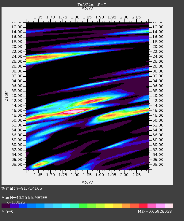
| Estimated Moho Depth: |
46.25 km |
| Estimated Crust Vp/Vs: |
1.80 |
| Assumed Crust Vp: |
6.419 km/s |
| Estimated Crust Vs: |
3.561 km/s |
| Estimated Crust Poisson's Ratio: |
0.28 |
|
| Radial Match: |
91.714165 % |
| Radial Bump: |
400 |
| Transverse Match: |
77.81148 % |
| Transverse Bump: |
400 |
| SOD ConfigId: |
2658 |
| Insert Time: |
2010-03-06 23:47:24.726 +0000 |
| GWidth: |
2.5 |
| Max Bumps: |
400 |
| Tol: |
0.001 |
|

Signal To Noise
| Channel | StoN | STA | LTA |
| TA:V24A: :BHZ:20090421T05:36:28.100017Z | 10.835833 | 1.3064198E-6 | 1.2056478E-7 |
| TA:V24A: :BHN:20090421T05:36:28.100017Z | 4.99722 | 4.864648E-7 | 9.734708E-8 |
| TA:V24A: :BHE:20090421T05:36:28.100017Z | 2.8160295 | 3.1419168E-7 | 1.11572575E-7 |
| Arrivals |
| Ps | 6.0 SECOND |
| PpPs | 19 SECOND |
| PsPs/PpSs | 25 SECOND |


