You are here: Home > Network List > TA - USArray Transportable Network (new EarthScope stations) Stations List
> Station V24A Rampart Ranch, Las Vegas, NM, USA > Earthquake Result Viewer
V24A Rampart Ranch, Las Vegas, NM, USA - Earthquake Result Viewer
| Earthquake location: |
Off East Coast Of Honshu, Japan |
| Earthquake latitude/longitude: |
36.5/142.4 |
| Earthquake time(UTC): |
2008/12/20 (355) 10:29:23 GMT |
| Earthquake Depth: |
19 km |
| Earthquake Magnitude: |
6.0 MB, 6.3 MS, 6.3 MW, 6.3 MW |
| Earthquake Catalog/Contributor: |
WHDF/NEIC |
|
| Network: |
TA USArray Transportable Network (new EarthScope stations) |
| Station: |
V24A Rampart Ranch, Las Vegas, NM, USA |
| Lat/Lon: |
35.73 N/105.27 W |
| Elevation: |
2187 m |
|
| Distance: |
84.5 deg |
| Az: |
49.138 deg |
| Baz: |
311.536 deg |
| Ray Param: |
0.045426164 |
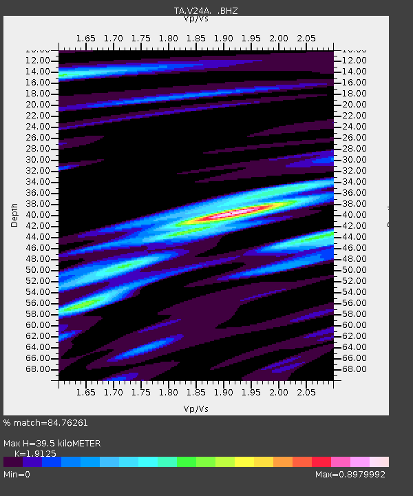
| Estimated Moho Depth: |
39.5 km |
| Estimated Crust Vp/Vs: |
1.91 |
| Assumed Crust Vp: |
6.419 km/s |
| Estimated Crust Vs: |
3.356 km/s |
| Estimated Crust Poisson's Ratio: |
0.31 |
|
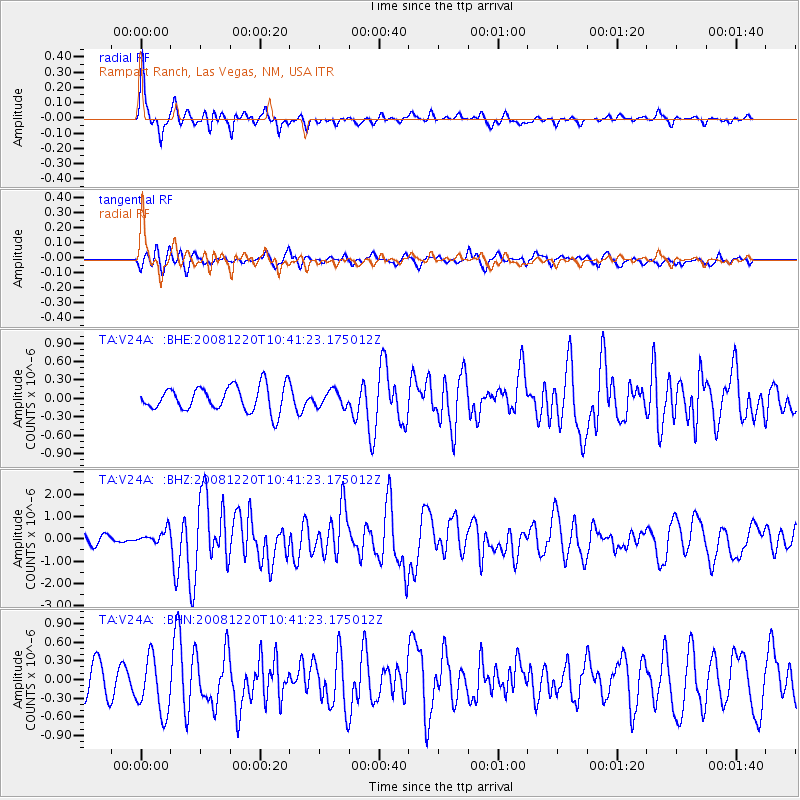
| Radial Match: |
84.76261 % |
| Radial Bump: |
400 |
| Transverse Match: |
57.272907 % |
| Transverse Bump: |
400 |
| SOD ConfigId: |
2658 |
| Insert Time: |
2010-03-06 23:47:26.885 +0000 |
| GWidth: |
2.5 |
| Max Bumps: |
400 |
| Tol: |
0.001 |
|
Signal To Noise
| Channel | StoN | STA | LTA |
| TA:V24A: :BHZ:20081220T10:41:23.175012Z | 1.786537 | 3.0080926E-7 | 1.683756E-7 |
| TA:V24A: :BHN:20081220T10:41:23.175012Z | 2.3383076 | 4.6616978E-7 | 1.9936203E-7 |
| TA:V24A: :BHE:20081220T10:41:23.175012Z | 0.62939465 | 1.2729187E-7 | 2.0224492E-7 |
| Arrivals |
| Ps | 5.7 SECOND |
| PpPs | 18 SECOND |
| PsPs/PpSs | 23 SECOND |


