You are here: Home > Network List > US - United States National Seismic Network Stations List
> Station DGMT Dagmar, Montana, USA > Earthquake Result Viewer
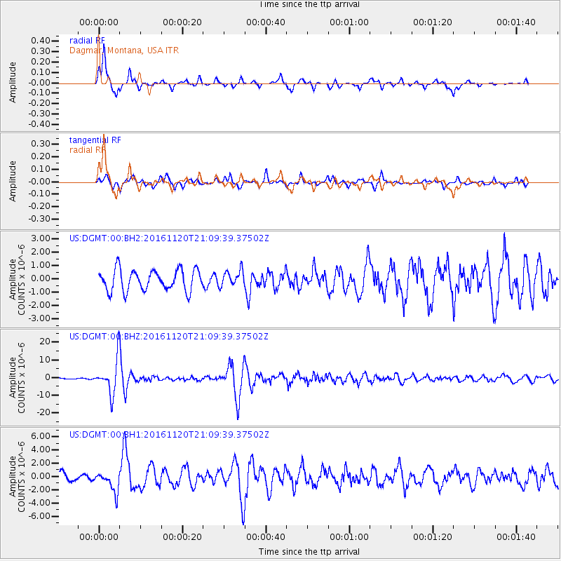
DGMT Dagmar, Montana, USA - Earthquake Result Viewer
*The percent match for this event was below the threshold and hence no stack was calculated.
| Earthquake location: |
San Juan Province, Argentina |
| Earthquake latitude/longitude: |
-31.6/-68.8 |
| Earthquake time(UTC): |
2016/11/20 (325) 20:57:43 GMT |
| Earthquake Depth: |
116 km |
| Earthquake Magnitude: |
6.4 MWP, 6.5 MWB |
| Earthquake Catalog/Contributor: |
NEIC PDE/NEIC COMCAT |
|
| Network: |
US United States National Seismic Network |
| Station: |
DGMT Dagmar, Montana, USA |
| Lat/Lon: |
48.47 N/104.20 W |
| Elevation: |
0.0 m |
|
| Distance: |
85.8 deg |
| Az: |
337.243 deg |
| Baz: |
150.28 deg |
| Ray Param: |
$rayparam |
*The percent match for this event was below the threshold and hence was not used in the summary stack. |
|
| Radial Match: |
84.718605 % |
| Radial Bump: |
316 |
| Transverse Match: |
75.7406 % |
| Transverse Bump: |
400 |
| SOD ConfigId: |
1858631 |
| Insert Time: |
2016-12-04 21:04:30.776 +0000 |
| GWidth: |
2.5 |
| Max Bumps: |
400 |
| Tol: |
0.001 |
|
Signal To Noise
| Channel | StoN | STA | LTA |
| US:DGMT:00:BHZ:20161120T21:09:39.37502Z | 51.999 | 9.808275E-6 | 1.8862428E-7 |
| US:DGMT:00:BH1:20161120T21:09:39.37502Z | 1.8886919 | 1.5786206E-6 | 8.358275E-7 |
| US:DGMT:00:BH2:20161120T21:09:39.37502Z | 0.7739376 | 6.073346E-7 | 7.8473334E-7 |
| Arrivals |
| Ps | |
| PpPs | |
| PsPs/PpSs | |


