You are here: Home > Network List > AV - Alaska Volcano Observatory Stations List
> Station MAPS Pakushin Southeast, Makushin Volcano, Alaska > Earthquake Result Viewer
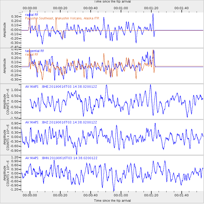
MAPS Pakushin Southeast, Makushin Volcano, Alaska - Earthquake Result Viewer
*The percent match for this event was below the threshold and hence no stack was calculated.
| Earthquake location: |
Kermadec Islands, New Zealand |
| Earthquake latitude/longitude: |
-30.7/-178.0 |
| Earthquake time(UTC): |
2019/06/16 (167) 03:02:38 GMT |
| Earthquake Depth: |
33 km |
| Earthquake Magnitude: |
5.5 mb |
| Earthquake Catalog/Contributor: |
NEIC PDE/us |
|
| Network: |
AV Alaska Volcano Observatory |
| Station: |
MAPS Pakushin Southeast, Makushin Volcano, Alaska |
| Lat/Lon: |
53.81 N/166.94 W |
| Elevation: |
333 m |
|
| Distance: |
84.7 deg |
| Az: |
6.541 deg |
| Baz: |
189.52 deg |
| Ray Param: |
$rayparam |
*The percent match for this event was below the threshold and hence was not used in the summary stack. |
|
| Radial Match: |
34.88382 % |
| Radial Bump: |
297 |
| Transverse Match: |
49.297688 % |
| Transverse Bump: |
287 |
| SOD ConfigId: |
18369291 |
| Insert Time: |
2019-06-30 03:03:39.886 +0000 |
| GWidth: |
2.5 |
| Max Bumps: |
400 |
| Tol: |
0.001 |
|
Signal To Noise
| Channel | StoN | STA | LTA |
| AV:MAPS: :BHZ:20190616T03:14:38.020012Z | 0.94551283 | 3.4151577E-7 | 3.6119633E-7 |
| AV:MAPS: :BHN:20190616T03:14:38.020012Z | 0.9257072 | 4.0417598E-7 | 4.3661316E-7 |
| AV:MAPS: :BHE:20190616T03:14:38.020012Z | 1.741312 | 6.4683263E-7 | 3.714628E-7 |
| Arrivals |
| Ps | |
| PpPs | |
| PsPs/PpSs | |


