You are here: Home > Network List > CI - Caltech Regional Seismic Network Stations List
> Station MPM Manuel Prospect Mine, California, USA > Earthquake Result Viewer
MPM Manuel Prospect Mine, California, USA - Earthquake Result Viewer
| Earthquake location: |
Kermadec Islands Region |
| Earthquake latitude/longitude: |
-31.7/-177.5 |
| Earthquake time(UTC): |
2019/06/16 (167) 05:17:03 GMT |
| Earthquake Depth: |
111 km |
| Earthquake Magnitude: |
6.6 Mi |
| Earthquake Catalog/Contributor: |
NEIC PDE/at |
|
| Network: |
CI Caltech Regional Seismic Network |
| Station: |
MPM Manuel Prospect Mine, California, USA |
| Lat/Lon: |
36.06 N/117.49 W |
| Elevation: |
185 m |
|
| Distance: |
87.8 deg |
| Az: |
44.615 deg |
| Baz: |
227.631 deg |
| Ray Param: |
0.0428401 |
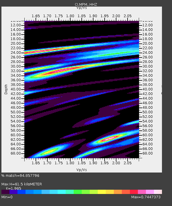
| Estimated Moho Depth: |
61.5 km |
| Estimated Crust Vp/Vs: |
1.97 |
| Assumed Crust Vp: |
6.279 km/s |
| Estimated Crust Vs: |
3.195 km/s |
| Estimated Crust Poisson's Ratio: |
0.33 |
|
| Radial Match: |
94.857796 % |
| Radial Bump: |
400 |
| Transverse Match: |
87.458916 % |
| Transverse Bump: |
400 |
| SOD ConfigId: |
18369291 |
| Insert Time: |
2019-06-30 05:18:45.069 +0000 |
| GWidth: |
2.5 |
| Max Bumps: |
400 |
| Tol: |
0.001 |
|
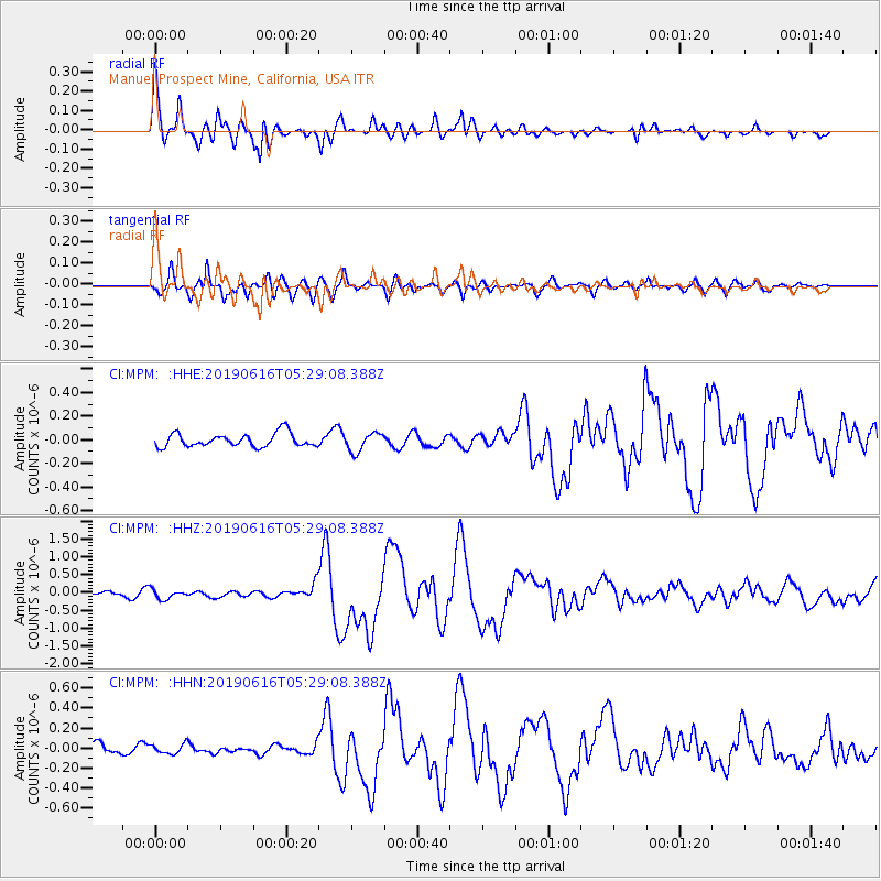
Signal To Noise
| Channel | StoN | STA | LTA |
| CI:MPM: :HHZ:20190616T05:29:08.388Z | 2.4973652 | 1.342639E-7 | 5.3762218E-8 |
| CI:MPM: :HHN:20190616T05:29:08.388Z | 0.8488516 | 4.8591428E-8 | 5.7243724E-8 |
| CI:MPM: :HHE:20190616T05:29:08.388Z | 1.4092295 | 8.031042E-8 | 5.6988885E-8 |
| Arrivals |
| Ps | 9.6 SECOND |
| PpPs | 29 SECOND |
| PsPs/PpSs | 38 SECOND |


