You are here: Home > Network List > WY - Yellowstone Wyoming Seismic Network Stations List
> Station YHR Hawk's Rest, WY, USA > Earthquake Result Viewer
YHR Hawk's Rest, WY, USA - Earthquake Result Viewer
| Earthquake location: |
Kermadec Islands Region |
| Earthquake latitude/longitude: |
-31.7/-177.5 |
| Earthquake time(UTC): |
2019/06/16 (167) 05:17:03 GMT |
| Earthquake Depth: |
111 km |
| Earthquake Magnitude: |
6.6 Mi |
| Earthquake Catalog/Contributor: |
NEIC PDE/at |
|
| Network: |
WY Yellowstone Wyoming Seismic Network |
| Station: |
YHR Hawk's Rest, WY, USA |
| Lat/Lon: |
44.11 N/110.08 W |
| Elevation: |
2976 m |
|
| Distance: |
97.3 deg |
| Az: |
42.112 deg |
| Baz: |
232.509 deg |
| Ray Param: |
0.040169135 |
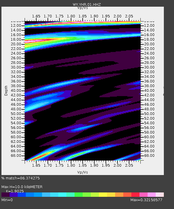
| Estimated Moho Depth: |
10.0 km |
| Estimated Crust Vp/Vs: |
1.90 |
| Assumed Crust Vp: |
6.35 km/s |
| Estimated Crust Vs: |
3.338 km/s |
| Estimated Crust Poisson's Ratio: |
0.31 |
|
| Radial Match: |
86.374275 % |
| Radial Bump: |
400 |
| Transverse Match: |
97.979294 % |
| Transverse Bump: |
183 |
| SOD ConfigId: |
18369291 |
| Insert Time: |
2019-06-30 05:21:20.224 +0000 |
| GWidth: |
2.5 |
| Max Bumps: |
400 |
| Tol: |
0.001 |
|

Signal To Noise
| Channel | StoN | STA | LTA |
| WY:YHR:01:HHZ:20190616T05:29:52.018005Z | 1.1434613 | 4.7621096E-8 | 4.164644E-8 |
| WY:YHR:01:HHN:20190616T05:29:52.018005Z | 1.1233186 | 5.9540454E-8 | 5.300407E-8 |
| WY:YHR:01:HHE:20190616T05:29:52.018005Z | 1.2124714 | 3.560404E-8 | 2.936485E-8 |
| Arrivals |
| Ps | 1.4 SECOND |
| PpPs | 4.5 SECOND |
| PsPs/PpSs | 5.9 SECOND |


