You are here: Home > Network List > AU - Australian Seismological Centre Stations List
> Station MTN Manton Dam, Northern Territory > Earthquake Result Viewer
MTN Manton Dam, Northern Territory - Earthquake Result Viewer
| Earthquake location: |
Kermadec Islands Region |
| Earthquake latitude/longitude: |
-31.1/-178.0 |
| Earthquake time(UTC): |
2019/06/16 (167) 05:17:16 GMT |
| Earthquake Depth: |
35 km |
| Earthquake Magnitude: |
6.3 Mww |
| Earthquake Catalog/Contributor: |
NEIC PDE/us |
|
| Network: |
AU Australian Seismological Centre |
| Station: |
MTN Manton Dam, Northern Territory |
| Lat/Lon: |
12.84 S/131.13 E |
| Elevation: |
137 m |
|
| Distance: |
50.1 deg |
| Az: |
279.506 deg |
| Baz: |
119.797 deg |
| Ray Param: |
0.06823202 |
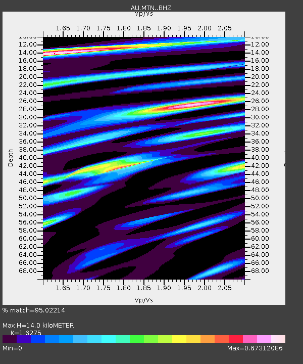
| Estimated Moho Depth: |
14.0 km |
| Estimated Crust Vp/Vs: |
1.63 |
| Assumed Crust Vp: |
6.61 km/s |
| Estimated Crust Vs: |
4.061 km/s |
| Estimated Crust Poisson's Ratio: |
0.20 |
|
| Radial Match: |
95.02214 % |
| Radial Bump: |
400 |
| Transverse Match: |
76.9698 % |
| Transverse Bump: |
400 |
| SOD ConfigId: |
18369291 |
| Insert Time: |
2019-06-30 05:22:41.675 +0000 |
| GWidth: |
2.5 |
| Max Bumps: |
400 |
| Tol: |
0.001 |
|

Signal To Noise
| Channel | StoN | STA | LTA |
| AU:MTN: :BHZ:20190616T05:25:37.544013Z | 18.362827 | 3.4056861E-6 | 1.8546633E-7 |
| AU:MTN: :BHN:20190616T05:25:37.544013Z | 7.511809 | 7.092168E-7 | 9.4413586E-8 |
| AU:MTN: :BHE:20190616T05:25:37.544013Z | 14.610178 | 1.5713996E-6 | 1.0755513E-7 |
| Arrivals |
| Ps | 1.4 SECOND |
| PpPs | 5.2 SECOND |
| PsPs/PpSs | 6.6 SECOND |


