You are here: Home > Network List > US - United States National Seismic Network Stations List
> Station OGNE Ogallala, Nebraska, USA > Earthquake Result Viewer
OGNE Ogallala, Nebraska, USA - Earthquake Result Viewer

| Earthquake location: |
San Juan Province, Argentina |
| Earthquake latitude/longitude: |
-31.6/-68.8 |
| Earthquake time(UTC): |
2016/11/20 (325) 20:57:43 GMT |
| Earthquake Depth: |
116 km |
| Earthquake Magnitude: |
6.4 MWP, 6.5 MWB |
| Earthquake Catalog/Contributor: |
NEIC PDE/NEIC COMCAT |
|
| Network: |
US United States National Seismic Network |
| Station: |
OGNE Ogallala, Nebraska, USA |
| Lat/Lon: |
40.95 N/102.03 W |
| Elevation: |
1054 m |
|
| Distance: |
78.5 deg |
| Az: |
334.909 deg |
| Baz: |
151.481 deg |
| Ray Param: |
0.049331788 |
| Estimated Moho Depth: |
15.5 km |
| Estimated Crust Vp/Vs: |
1.67 |
| Assumed Crust Vp: |
6.483 km/s |
| Estimated Crust Vs: |
3.876 km/s |
| Estimated Crust Poisson's Ratio: |
0.22 |
|
| Radial Match: |
94.20458 % |
| Radial Bump: |
359 |
| Transverse Match: |
91.607025 % |
| Transverse Bump: |
366 |
| SOD ConfigId: |
1858631 |
| Insert Time: |
2016-12-04 21:05:26.607 +0000 |
| GWidth: |
2.5 |
| Max Bumps: |
400 |
| Tol: |
0.001 |
|
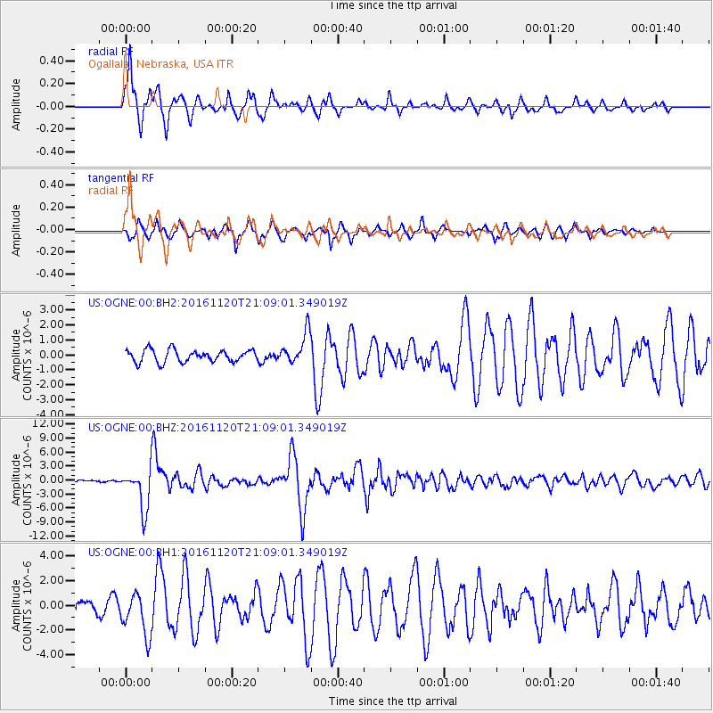
Signal To Noise
| Channel | StoN | STA | LTA |
| US:OGNE:00:BHZ:20161120T21:09:01.349019Z | 27.103828 | 4.435325E-6 | 1.6364201E-7 |
| US:OGNE:00:BH1:20161120T21:09:01.349019Z | 3.860827 | 1.7535634E-6 | 4.5419375E-7 |
| US:OGNE:00:BH2:20161120T21:09:01.349019Z | 2.65094 | 1.0767737E-6 | 4.0618565E-7 |
| Arrivals |
| Ps | 1.7 SECOND |
| PpPs | 6.2 SECOND |
| PsPs/PpSs | 7.9 SECOND |


