You are here: Home > Network List > CI - Caltech Regional Seismic Network Stations List
> Station GMR Granite Mountains Research Center > Earthquake Result Viewer
GMR Granite Mountains Research Center - Earthquake Result Viewer
| Earthquake location: |
Kermadec Islands Region |
| Earthquake latitude/longitude: |
-31.1/-178.0 |
| Earthquake time(UTC): |
2019/06/16 (167) 05:17:16 GMT |
| Earthquake Depth: |
35 km |
| Earthquake Magnitude: |
6.3 Mww |
| Earthquake Catalog/Contributor: |
NEIC PDE/us |
|
| Network: |
CI Caltech Regional Seismic Network |
| Station: |
GMR Granite Mountains Research Center |
| Lat/Lon: |
34.78 N/115.66 W |
| Elevation: |
1326 m |
|
| Distance: |
87.9 deg |
| Az: |
46.858 deg |
| Baz: |
229.528 deg |
| Ray Param: |
0.0429153 |
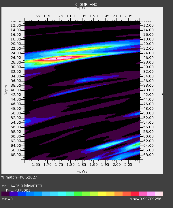
| Estimated Moho Depth: |
26.0 km |
| Estimated Crust Vp/Vs: |
1.74 |
| Assumed Crust Vp: |
6.276 km/s |
| Estimated Crust Vs: |
3.612 km/s |
| Estimated Crust Poisson's Ratio: |
0.25 |
|
| Radial Match: |
96.52027 % |
| Radial Bump: |
375 |
| Transverse Match: |
89.18329 % |
| Transverse Bump: |
400 |
| SOD ConfigId: |
18369291 |
| Insert Time: |
2019-06-30 05:24:29.718 +0000 |
| GWidth: |
2.5 |
| Max Bumps: |
400 |
| Tol: |
0.001 |
|
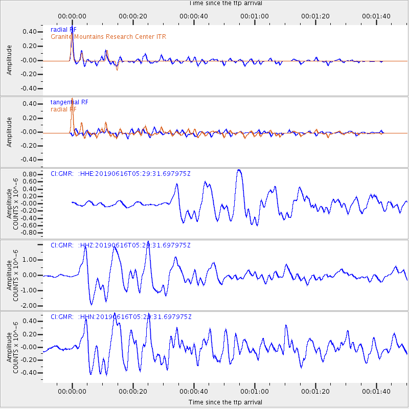
Signal To Noise
| Channel | StoN | STA | LTA |
| CI:GMR: :HHZ:20190616T05:29:31.697975Z | 15.012536 | 8.2242804E-7 | 5.4782753E-8 |
| CI:GMR: :HHN:20190616T05:29:31.697975Z | 3.433157 | 1.754922E-7 | 5.111686E-8 |
| CI:GMR: :HHE:20190616T05:29:31.697975Z | 4.6725492 | 2.3506632E-7 | 5.030794E-8 |
| Arrivals |
| Ps | 3.1 SECOND |
| PpPs | 11 SECOND |
| PsPs/PpSs | 14 SECOND |


