You are here: Home > Network List > TA - USArray Transportable Network (new EarthScope stations) Stations List
> Station A21A Bergtoll Ranch, Theony, MT, USA > Earthquake Result Viewer
A21A Bergtoll Ranch, Theony, MT, USA - Earthquake Result Viewer
| Earthquake location: |
Kermadec Islands Region |
| Earthquake latitude/longitude: |
-27.4/-176.3 |
| Earthquake time(UTC): |
2009/02/18 (049) 21:53:45 GMT |
| Earthquake Depth: |
25 km |
| Earthquake Magnitude: |
6.8 MB, 7.2 MS, 6.9 MW, 6.9 MW |
| Earthquake Catalog/Contributor: |
WHDF/NEIC |
|
| Network: |
TA USArray Transportable Network (new EarthScope stations) |
| Station: |
A21A Bergtoll Ranch, Theony, MT, USA |
| Lat/Lon: |
48.99 N/106.93 W |
| Elevation: |
779 m |
|
| Distance: |
98.0 deg |
| Az: |
38.507 deg |
| Baz: |
237.161 deg |
| Ray Param: |
0.04003762 |
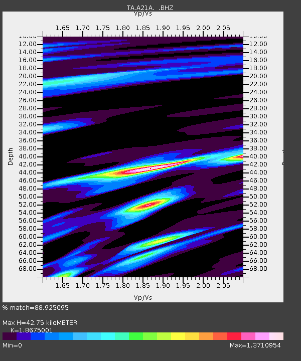
| Estimated Moho Depth: |
42.75 km |
| Estimated Crust Vp/Vs: |
1.87 |
| Assumed Crust Vp: |
6.438 km/s |
| Estimated Crust Vs: |
3.447 km/s |
| Estimated Crust Poisson's Ratio: |
0.30 |
|
| Radial Match: |
88.925095 % |
| Radial Bump: |
268 |
| Transverse Match: |
80.70996 % |
| Transverse Bump: |
337 |
| SOD ConfigId: |
2658 |
| Insert Time: |
2010-03-06 23:50:31.286 +0000 |
| GWidth: |
2.5 |
| Max Bumps: |
400 |
| Tol: |
0.001 |
|
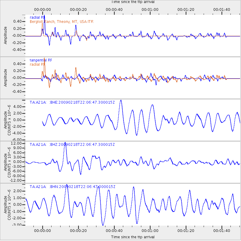
Signal To Noise
| Channel | StoN | STA | LTA |
| TA:A21A: :BHZ:20090218T22:06:47.300015Z | 2.0876021 | 6.565243E-7 | 3.144873E-7 |
| TA:A21A: :BHN:20090218T22:06:47.300015Z | 1.7677231 | 8.928857E-7 | 5.0510494E-7 |
| TA:A21A: :BHE:20090218T22:06:47.300015Z | 1.6149884 | 1.3999143E-6 | 8.6682616E-7 |
| Arrivals |
| Ps | 5.9 SECOND |
| PpPs | 19 SECOND |
| PsPs/PpSs | 25 SECOND |


