You are here: Home > Network List > TA - USArray Transportable Network (new EarthScope stations) Stations List
> Station A21A Bergtoll Ranch, Theony, MT, USA > Earthquake Result Viewer
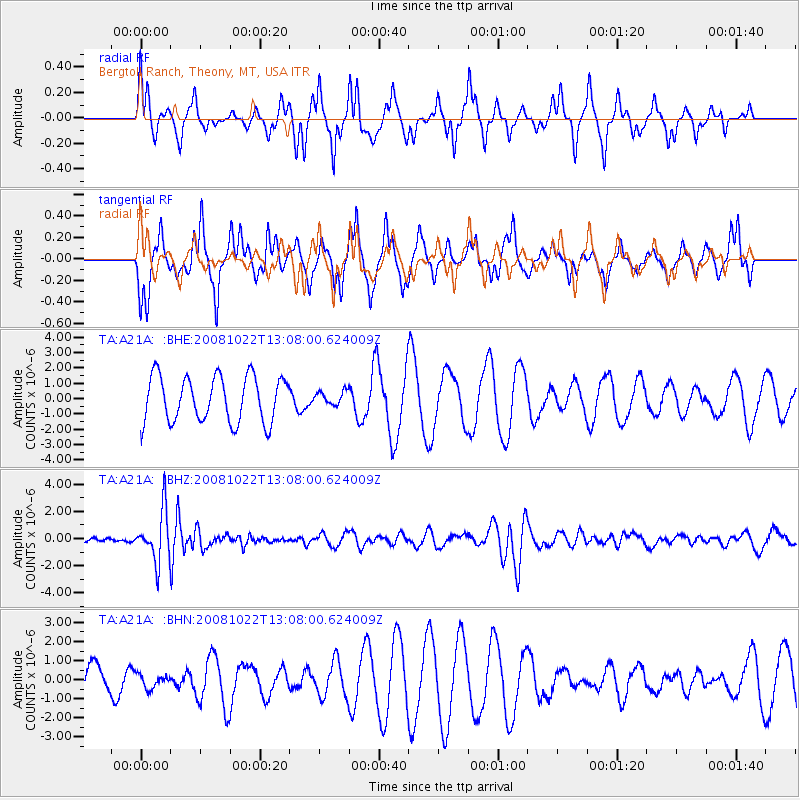
A21A Bergtoll Ranch, Theony, MT, USA - Earthquake Result Viewer
*The percent match for this event was below the threshold and hence no stack was calculated.
| Earthquake location: |
Tonga Islands |
| Earthquake latitude/longitude: |
-18.4/-175.4 |
| Earthquake time(UTC): |
2008/10/22 (296) 12:55:57 GMT |
| Earthquake Depth: |
233 km |
| Earthquake Magnitude: |
5.9 MB, 6.4 MW, 6.3 MW |
| Earthquake Catalog/Contributor: |
WHDF/NEIC |
|
| Network: |
TA USArray Transportable Network (new EarthScope stations) |
| Station: |
A21A Bergtoll Ranch, Theony, MT, USA |
| Lat/Lon: |
48.99 N/106.93 W |
| Elevation: |
779 m |
|
| Distance: |
90.4 deg |
| Az: |
37.774 deg |
| Baz: |
241.998 deg |
| Ray Param: |
$rayparam |
*The percent match for this event was below the threshold and hence was not used in the summary stack. |
|
| Radial Match: |
39.39005 % |
| Radial Bump: |
229 |
| Transverse Match: |
60.25308 % |
| Transverse Bump: |
282 |
| SOD ConfigId: |
2560 |
| Insert Time: |
2010-03-06 23:50:47.725 +0000 |
| GWidth: |
2.5 |
| Max Bumps: |
400 |
| Tol: |
0.001 |
|
Signal To Noise
| Channel | StoN | STA | LTA |
| TA:A21A: :BHZ:20081022T13:08:00.624009Z | 6.5125613 | 1.8642872E-6 | 2.8626022E-7 |
| TA:A21A: :BHN:20081022T13:08:00.624009Z | 0.3406859 | 3.612494E-7 | 1.0603592E-6 |
| TA:A21A: :BHE:20081022T13:08:00.624009Z | 0.28891435 | 4.283474E-7 | 1.4826103E-6 |
| Arrivals |
| Ps | |
| PpPs | |
| PsPs/PpSs | |


