You are here: Home > Network List > NN - Western Great Basin/Eastern Sierra Nevada Stations List
> Station DSP Deep Springs, California w84gm > Earthquake Result Viewer
DSP Deep Springs, California w84gm - Earthquake Result Viewer
| Earthquake location: |
Kermadec Islands Region |
| Earthquake latitude/longitude: |
-31.1/-178.0 |
| Earthquake time(UTC): |
2019/06/16 (167) 05:17:16 GMT |
| Earthquake Depth: |
35 km |
| Earthquake Magnitude: |
6.3 Mww |
| Earthquake Catalog/Contributor: |
NEIC PDE/us |
|
| Network: |
NN Western Great Basin/Eastern Sierra Nevada |
| Station: |
DSP Deep Springs, California w84gm |
| Lat/Lon: |
37.37 N/117.97 W |
| Elevation: |
1692 m |
|
| Distance: |
88.2 deg |
| Az: |
43.683 deg |
| Baz: |
228.066 deg |
| Ray Param: |
0.042700995 |
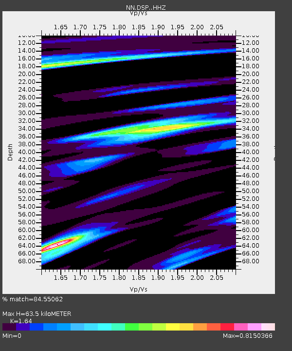
| Estimated Moho Depth: |
63.5 km |
| Estimated Crust Vp/Vs: |
1.64 |
| Assumed Crust Vp: |
6.279 km/s |
| Estimated Crust Vs: |
3.828 km/s |
| Estimated Crust Poisson's Ratio: |
0.20 |
|
| Radial Match: |
84.55062 % |
| Radial Bump: |
400 |
| Transverse Match: |
76.28376 % |
| Transverse Bump: |
400 |
| SOD ConfigId: |
18369291 |
| Insert Time: |
2019-06-30 05:26:25.266 +0000 |
| GWidth: |
2.5 |
| Max Bumps: |
400 |
| Tol: |
0.001 |
|

Signal To Noise
| Channel | StoN | STA | LTA |
| NN:DSP: :HHZ:20190616T05:29:33.06797Z | 10.349697 | 6.628234E-7 | 6.404279E-8 |
| NN:DSP: :HHN:20190616T05:29:33.06797Z | 1.7888749 | 1.0838336E-7 | 6.0587446E-8 |
| NN:DSP: :HHE:20190616T05:29:33.06797Z | 2.6953921 | 1.5640931E-7 | 5.802841E-8 |
| Arrivals |
| Ps | 6.6 SECOND |
| PpPs | 26 SECOND |
| PsPs/PpSs | 33 SECOND |


