You are here: Home > Network List > TA - USArray Transportable Network (new EarthScope stations) Stations List
> Station G16K Koyuk River, AK, USA > Earthquake Result Viewer
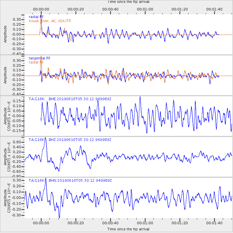
G16K Koyuk River, AK, USA - Earthquake Result Viewer
*The percent match for this event was below the threshold and hence no stack was calculated.
| Earthquake location: |
Kermadec Islands Region |
| Earthquake latitude/longitude: |
-31.1/-178.0 |
| Earthquake time(UTC): |
2019/06/16 (167) 05:17:16 GMT |
| Earthquake Depth: |
35 km |
| Earthquake Magnitude: |
6.3 Mww |
| Earthquake Catalog/Contributor: |
NEIC PDE/us |
|
| Network: |
TA USArray Transportable Network (new EarthScope stations) |
| Station: |
G16K Koyuk River, AK, USA |
| Lat/Lon: |
65.39 N/162.35 W |
| Elevation: |
169 m |
|
| Distance: |
96.9 deg |
| Az: |
6.54 deg |
| Baz: |
193.501 deg |
| Ray Param: |
$rayparam |
*The percent match for this event was below the threshold and hence was not used in the summary stack. |
|
| Radial Match: |
72.059616 % |
| Radial Bump: |
400 |
| Transverse Match: |
55.291183 % |
| Transverse Bump: |
400 |
| SOD ConfigId: |
18369291 |
| Insert Time: |
2019-06-30 05:27:26.109 +0000 |
| GWidth: |
2.5 |
| Max Bumps: |
400 |
| Tol: |
0.001 |
|
Signal To Noise
| Channel | StoN | STA | LTA |
| TA:G16K: :BHZ:20190616T05:30:12.949989Z | 5.455926 | 3.8825277E-7 | 7.1161665E-8 |
| TA:G16K: :BHN:20190616T05:30:12.949989Z | 2.0181737 | 1.4124205E-7 | 6.9985084E-8 |
| TA:G16K: :BHE:20190616T05:30:12.949989Z | 1.2941331 | 7.529647E-8 | 5.8182945E-8 |
| Arrivals |
| Ps | |
| PpPs | |
| PsPs/PpSs | |


