You are here: Home > Network List > TA - USArray Transportable Network (new EarthScope stations) Stations List
> Station A21A Bergtoll Ranch, Theony, MT, USA > Earthquake Result Viewer
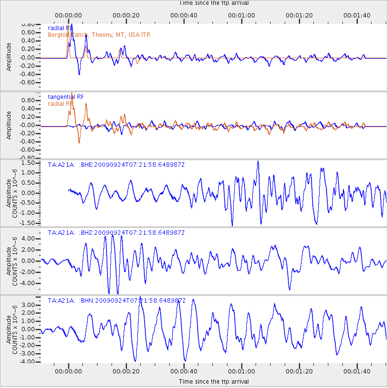
A21A Bergtoll Ranch, Theony, MT, USA - Earthquake Result Viewer
*The percent match for this event was below the threshold and hence no stack was calculated.
| Earthquake location: |
Off Coast Of Jalisco, Mexico |
| Earthquake latitude/longitude: |
18.8/-107.3 |
| Earthquake time(UTC): |
2009/09/24 (267) 07:16:19 GMT |
| Earthquake Depth: |
10 km |
| Earthquake Magnitude: |
5.8 MB, 6.2 MS, 6.3 MW, 6.3 MW |
| Earthquake Catalog/Contributor: |
WHDF/NEIC |
|
| Network: |
TA USArray Transportable Network (new EarthScope stations) |
| Station: |
A21A Bergtoll Ranch, Theony, MT, USA |
| Lat/Lon: |
48.99 N/106.93 W |
| Elevation: |
779 m |
|
| Distance: |
30.1 deg |
| Az: |
0.551 deg |
| Baz: |
180.793 deg |
| Ray Param: |
$rayparam |
*The percent match for this event was below the threshold and hence was not used in the summary stack. |
|
| Radial Match: |
89.80164 % |
| Radial Bump: |
384 |
| Transverse Match: |
66.22219 % |
| Transverse Bump: |
400 |
| SOD ConfigId: |
2622 |
| Insert Time: |
2010-03-06 23:51:17.408 +0000 |
| GWidth: |
2.5 |
| Max Bumps: |
400 |
| Tol: |
0.001 |
|
Signal To Noise
| Channel | StoN | STA | LTA |
| TA:A21A: :BHZ:20090924T07:21:58.648987Z | 5.030181 | 1.1978109E-6 | 2.381248E-7 |
| TA:A21A: :BHN:20090924T07:21:58.648987Z | 2.539183 | 7.930762E-7 | 3.123352E-7 |
| TA:A21A: :BHE:20090924T07:21:58.648987Z | 0.8267418 | 2.4607888E-7 | 2.97649E-7 |
| Arrivals |
| Ps | |
| PpPs | |
| PsPs/PpSs | |


