You are here: Home > Network List > TA - USArray Transportable Network (new EarthScope stations) Stations List
> Station A21A Bergtoll Ranch, Theony, MT, USA > Earthquake Result Viewer
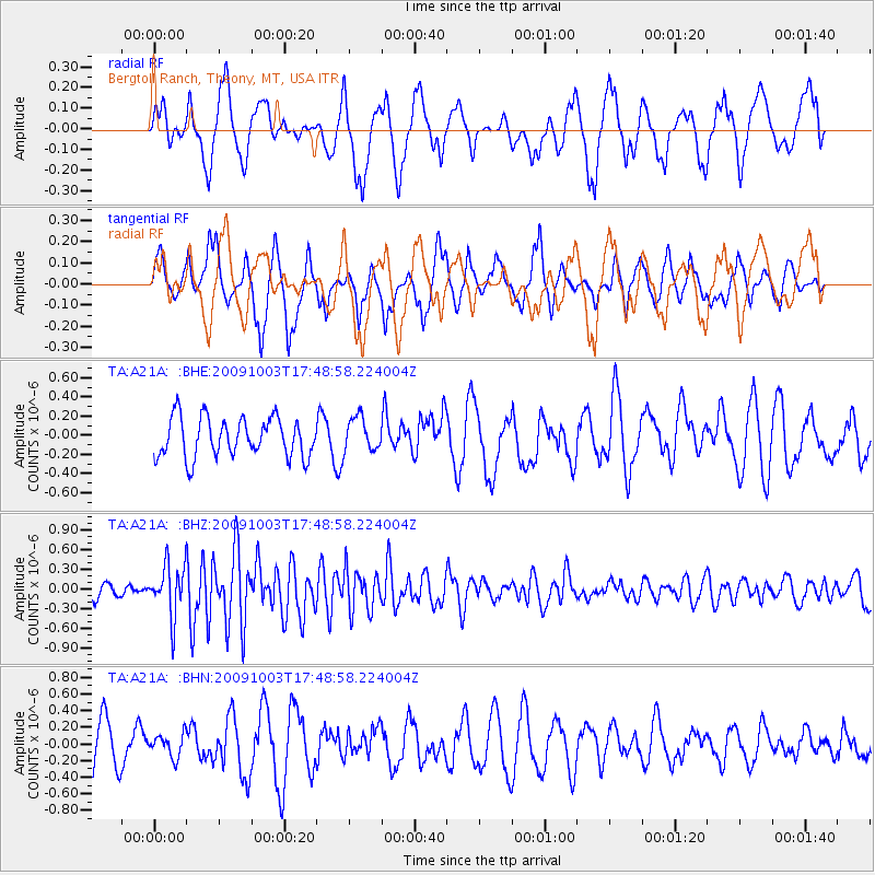
A21A Bergtoll Ranch, Theony, MT, USA - Earthquake Result Viewer
*The percent match for this event was below the threshold and hence no stack was calculated.
| Earthquake location: |
Taiwan |
| Earthquake latitude/longitude: |
23.6/121.5 |
| Earthquake time(UTC): |
2009/10/03 (276) 17:36:06 GMT |
| Earthquake Depth: |
28 km |
| Earthquake Magnitude: |
6.0 MB, 5.7 MS, 6.0 MW, 6.1 MW |
| Earthquake Catalog/Contributor: |
WHDF/NEIC |
|
| Network: |
TA USArray Transportable Network (new EarthScope stations) |
| Station: |
A21A Bergtoll Ranch, Theony, MT, USA |
| Lat/Lon: |
48.99 N/106.93 W |
| Elevation: |
779 m |
|
| Distance: |
95.8 deg |
| Az: |
29.666 deg |
| Baz: |
316.438 deg |
| Ray Param: |
$rayparam |
*The percent match for this event was below the threshold and hence was not used in the summary stack. |
|
| Radial Match: |
48.270306 % |
| Radial Bump: |
400 |
| Transverse Match: |
61.128155 % |
| Transverse Bump: |
344 |
| SOD ConfigId: |
2622 |
| Insert Time: |
2010-03-06 23:51:26.741 +0000 |
| GWidth: |
2.5 |
| Max Bumps: |
400 |
| Tol: |
0.001 |
|
Signal To Noise
| Channel | StoN | STA | LTA |
| TA:A21A: :BHZ:20091003T17:48:58.224004Z | 2.770644 | 3.86102E-7 | 1.393546E-7 |
| TA:A21A: :BHN:20091003T17:48:58.224004Z | 0.40145206 | 1.350052E-7 | 3.3629217E-7 |
| TA:A21A: :BHE:20091003T17:48:58.224004Z | 0.86182314 | 1.7695302E-7 | 2.0532407E-7 |
| Arrivals |
| Ps | |
| PpPs | |
| PsPs/PpSs | |


