You are here: Home > Network List > TA - USArray Transportable Network (new EarthScope stations) Stations List
> Station R33M Jennings River, BC, CAN > Earthquake Result Viewer
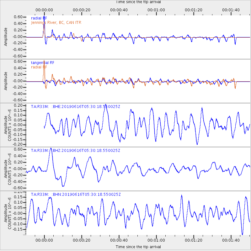
R33M Jennings River, BC, CAN - Earthquake Result Viewer
*The percent match for this event was below the threshold and hence no stack was calculated.
| Earthquake location: |
Kermadec Islands Region |
| Earthquake latitude/longitude: |
-31.1/-178.0 |
| Earthquake time(UTC): |
2019/06/16 (167) 05:17:16 GMT |
| Earthquake Depth: |
35 km |
| Earthquake Magnitude: |
6.3 Mww |
| Earthquake Catalog/Contributor: |
NEIC PDE/us |
|
| Network: |
TA USArray Transportable Network (new EarthScope stations) |
| Station: |
R33M Jennings River, BC, CAN |
| Lat/Lon: |
59.39 N/130.97 W |
| Elevation: |
1437 m |
|
| Distance: |
98.2 deg |
| Az: |
22.233 deg |
| Baz: |
219.391 deg |
| Ray Param: |
$rayparam |
*The percent match for this event was below the threshold and hence was not used in the summary stack. |
|
| Radial Match: |
75.03458 % |
| Radial Bump: |
400 |
| Transverse Match: |
46.2523 % |
| Transverse Bump: |
400 |
| SOD ConfigId: |
18369291 |
| Insert Time: |
2019-06-30 05:28:13.569 +0000 |
| GWidth: |
2.5 |
| Max Bumps: |
400 |
| Tol: |
0.001 |
|
Signal To Noise
| Channel | StoN | STA | LTA |
| TA:R33M: :BHZ:20190616T05:30:18.550025Z | 6.4278936 | 3.387861E-7 | 5.2705612E-8 |
| TA:R33M: :BHN:20190616T05:30:18.550025Z | 1.4368502 | 9.553982E-8 | 6.649254E-8 |
| TA:R33M: :BHE:20190616T05:30:18.550025Z | 1.7969701 | 1.1771603E-7 | 6.550806E-8 |
| Arrivals |
| Ps | |
| PpPs | |
| PsPs/PpSs | |


