You are here: Home > Network List > TA - USArray Transportable Network (new EarthScope stations) Stations List
> Station S12K Black Hills, AK, USA > Earthquake Result Viewer
S12K Black Hills, AK, USA - Earthquake Result Viewer
| Earthquake location: |
Kermadec Islands Region |
| Earthquake latitude/longitude: |
-31.1/-178.0 |
| Earthquake time(UTC): |
2019/06/16 (167) 05:17:16 GMT |
| Earthquake Depth: |
35 km |
| Earthquake Magnitude: |
6.3 Mww |
| Earthquake Catalog/Contributor: |
NEIC PDE/us |
|
| Network: |
TA USArray Transportable Network (new EarthScope stations) |
| Station: |
S12K Black Hills, AK, USA |
| Lat/Lon: |
55.70 N/162.06 W |
| Elevation: |
411 m |
|
| Distance: |
87.5 deg |
| Az: |
8.964 deg |
| Baz: |
193.663 deg |
| Ray Param: |
0.0432443 |
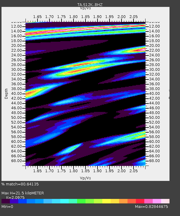
| Estimated Moho Depth: |
21.5 km |
| Estimated Crust Vp/Vs: |
2.10 |
| Assumed Crust Vp: |
5.989 km/s |
| Estimated Crust Vs: |
2.855 km/s |
| Estimated Crust Poisson's Ratio: |
0.35 |
|
| Radial Match: |
80.64135 % |
| Radial Bump: |
400 |
| Transverse Match: |
71.516365 % |
| Transverse Bump: |
400 |
| SOD ConfigId: |
18369291 |
| Insert Time: |
2019-06-30 05:28:14.434 +0000 |
| GWidth: |
2.5 |
| Max Bumps: |
400 |
| Tol: |
0.001 |
|

Signal To Noise
| Channel | StoN | STA | LTA |
| TA:S12K: :BHZ:20190616T05:29:29.574989Z | 10.265481 | 3.008558E-6 | 2.930752E-7 |
| TA:S12K: :BHN:20190616T05:29:29.574989Z | 2.3002615 | 6.8800955E-7 | 2.9910058E-7 |
| TA:S12K: :BHE:20190616T05:29:29.574989Z | 0.9087492 | 2.3686871E-7 | 2.6065356E-7 |
| Arrivals |
| Ps | 4.0 SECOND |
| PpPs | 11 SECOND |
| PsPs/PpSs | 15 SECOND |


