You are here: Home > Network List > TA - USArray Transportable Network (new EarthScope stations) Stations List
> Station A21A Bergtoll Ranch, Theony, MT, USA > Earthquake Result Viewer
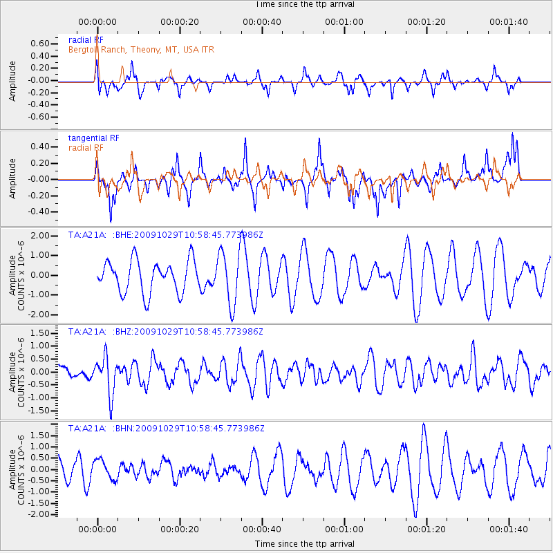
A21A Bergtoll Ranch, Theony, MT, USA - Earthquake Result Viewer
*The percent match for this event was below the threshold and hence no stack was calculated.
| Earthquake location: |
Veracruz, Mexico |
| Earthquake latitude/longitude: |
18.9/-95.5 |
| Earthquake time(UTC): |
2009/10/29 (302) 10:52:56 GMT |
| Earthquake Depth: |
16 km |
| Earthquake Magnitude: |
5.5 MB, 5.3 MS, 5.7 MW, 5.5 MD |
| Earthquake Catalog/Contributor: |
WHDF/NEIC |
|
| Network: |
TA USArray Transportable Network (new EarthScope stations) |
| Station: |
A21A Bergtoll Ranch, Theony, MT, USA |
| Lat/Lon: |
48.99 N/106.93 W |
| Elevation: |
779 m |
|
| Distance: |
31.4 deg |
| Az: |
345.539 deg |
| Baz: |
158.967 deg |
| Ray Param: |
$rayparam |
*The percent match for this event was below the threshold and hence was not used in the summary stack. |
|
| Radial Match: |
54.676083 % |
| Radial Bump: |
331 |
| Transverse Match: |
43.716564 % |
| Transverse Bump: |
318 |
| SOD ConfigId: |
2622 |
| Insert Time: |
2010-03-06 23:51:41.710 +0000 |
| GWidth: |
2.5 |
| Max Bumps: |
400 |
| Tol: |
0.001 |
|
Signal To Noise
| Channel | StoN | STA | LTA |
| TA:A21A: :BHZ:20091029T10:58:45.773986Z | 2.5712874 | 7.3886343E-7 | 2.8735155E-7 |
| TA:A21A: :BHN:20091029T10:58:45.773986Z | 0.7500638 | 4.382362E-7 | 5.8426525E-7 |
| TA:A21A: :BHE:20091029T10:58:45.773986Z | 1.7223686 | 1.3831598E-6 | 8.0305676E-7 |
| Arrivals |
| Ps | |
| PpPs | |
| PsPs/PpSs | |


