You are here: Home > Network List > TA - USArray Transportable Network (new EarthScope stations) Stations List
> Station A21A Bergtoll Ranch, Theony, MT, USA > Earthquake Result Viewer
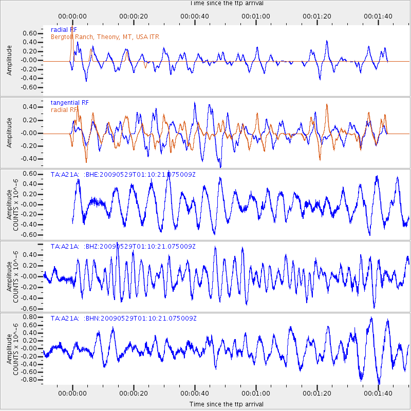
A21A Bergtoll Ranch, Theony, MT, USA - Earthquake Result Viewer
*The percent match for this event was below the threshold and hence no stack was calculated.
| Earthquake location: |
Off Coast Of Jalisco, Mexico |
| Earthquake latitude/longitude: |
18.4/-106.5 |
| Earthquake time(UTC): |
2009/05/29 (149) 01:04:38 GMT |
| Earthquake Depth: |
11 km |
| Earthquake Magnitude: |
5.5 MW, 5.0 MS, 5.0 MB, 5.3 MW |
| Earthquake Catalog/Contributor: |
WHDF/NEIC |
|
| Network: |
TA USArray Transportable Network (new EarthScope stations) |
| Station: |
A21A Bergtoll Ranch, Theony, MT, USA |
| Lat/Lon: |
48.99 N/106.93 W |
| Elevation: |
779 m |
|
| Distance: |
30.5 deg |
| Az: |
359.494 deg |
| Baz: |
179.27 deg |
| Ray Param: |
$rayparam |
*The percent match for this event was below the threshold and hence was not used in the summary stack. |
|
| Radial Match: |
48.094997 % |
| Radial Bump: |
281 |
| Transverse Match: |
57.719395 % |
| Transverse Bump: |
298 |
| SOD ConfigId: |
2648 |
| Insert Time: |
2010-03-06 23:51:48.870 +0000 |
| GWidth: |
2.5 |
| Max Bumps: |
400 |
| Tol: |
0.001 |
|
Signal To Noise
| Channel | StoN | STA | LTA |
| TA:A21A: :BHZ:20090529T01:10:21.075009Z | 1.9131006 | 1.9639184E-7 | 1.0265631E-7 |
| TA:A21A: :BHN:20090529T01:10:21.075009Z | 0.57373226 | 1.0172415E-7 | 1.7730248E-7 |
| TA:A21A: :BHE:20090529T01:10:21.075009Z | 1.7123573 | 3.784532E-7 | 2.2101297E-7 |
| Arrivals |
| Ps | |
| PpPs | |
| PsPs/PpSs | |


