You are here: Home > Network List > TA - USArray Transportable Network (new EarthScope stations) Stations List
> Station A21A Bergtoll Ranch, Theony, MT, USA > Earthquake Result Viewer
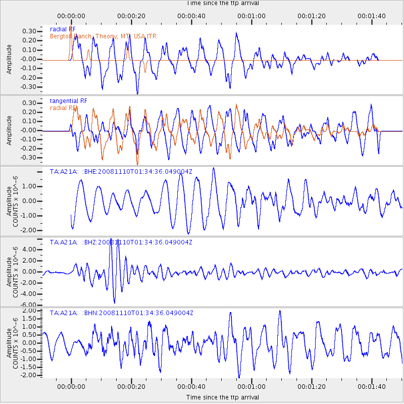
A21A Bergtoll Ranch, Theony, MT, USA - Earthquake Result Viewer
*The percent match for this event was below the threshold and hence no stack was calculated.
| Earthquake location: |
Qinghai, China |
| Earthquake latitude/longitude: |
37.6/95.8 |
| Earthquake time(UTC): |
2008/11/10 (315) 01:22:02 GMT |
| Earthquake Depth: |
19 km |
| Earthquake Magnitude: |
6.4 MB, 6.4 MS, 6.3 MW, 6.3 MW |
| Earthquake Catalog/Contributor: |
WHDF/NEIC |
|
| Network: |
TA USArray Transportable Network (new EarthScope stations) |
| Station: |
A21A Bergtoll Ranch, Theony, MT, USA |
| Lat/Lon: |
48.99 N/106.93 W |
| Elevation: |
779 m |
|
| Distance: |
91.5 deg |
| Az: |
14.767 deg |
| Baz: |
342.091 deg |
| Ray Param: |
$rayparam |
*The percent match for this event was below the threshold and hence was not used in the summary stack. |
|
| Radial Match: |
38.463715 % |
| Radial Bump: |
400 |
| Transverse Match: |
44.116142 % |
| Transverse Bump: |
400 |
| SOD ConfigId: |
2658 |
| Insert Time: |
2010-03-06 23:51:49.921 +0000 |
| GWidth: |
2.5 |
| Max Bumps: |
400 |
| Tol: |
0.001 |
|
Signal To Noise
| Channel | StoN | STA | LTA |
| TA:A21A: :BHZ:20081110T01:34:36.049004Z | 3.2097285 | 7.5201086E-7 | 2.3429112E-7 |
| TA:A21A: :BHN:20081110T01:34:36.049004Z | 0.4944701 | 3.4648093E-7 | 7.007116E-7 |
| TA:A21A: :BHE:20081110T01:34:36.049004Z | 1.4726483 | 1.1408869E-6 | 7.747178E-7 |
| Arrivals |
| Ps | |
| PpPs | |
| PsPs/PpSs | |


