You are here: Home > Network List > TA - USArray Transportable Network (new EarthScope stations) Stations List
> Station A21A Bergtoll Ranch, Theony, MT, USA > Earthquake Result Viewer
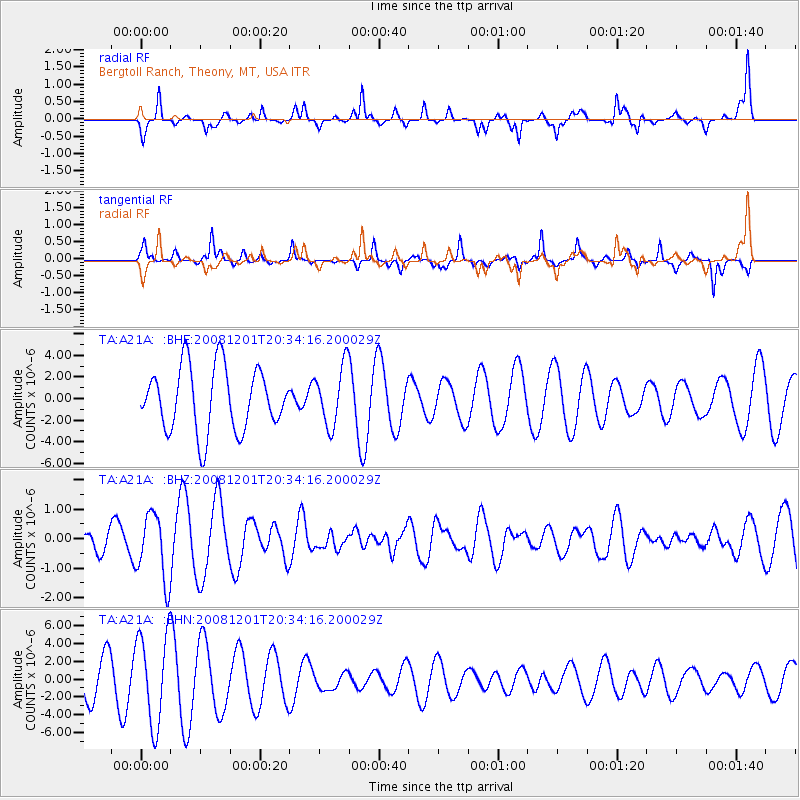
A21A Bergtoll Ranch, Theony, MT, USA - Earthquake Result Viewer
*The percent match for this event was below the threshold and hence no stack was calculated.
| Earthquake location: |
Tonga Islands Region |
| Earthquake latitude/longitude: |
-22.9/-175.2 |
| Earthquake time(UTC): |
2008/12/01 (336) 20:21:34 GMT |
| Earthquake Depth: |
39 km |
| Earthquake Magnitude: |
5.5 MB, 5.1 MS |
| Earthquake Catalog/Contributor: |
WHDF/NEIC |
|
| Network: |
TA USArray Transportable Network (new EarthScope stations) |
| Station: |
A21A Bergtoll Ranch, Theony, MT, USA |
| Lat/Lon: |
48.99 N/106.93 W |
| Elevation: |
779 m |
|
| Distance: |
93.8 deg |
| Az: |
37.823 deg |
| Baz: |
239.117 deg |
| Ray Param: |
$rayparam |
*The percent match for this event was below the threshold and hence was not used in the summary stack. |
|
| Radial Match: |
58.61632 % |
| Radial Bump: |
290 |
| Transverse Match: |
72.63296 % |
| Transverse Bump: |
268 |
| SOD ConfigId: |
2658 |
| Insert Time: |
2010-03-06 23:51:58.722 +0000 |
| GWidth: |
2.5 |
| Max Bumps: |
400 |
| Tol: |
0.001 |
|
Signal To Noise
| Channel | StoN | STA | LTA |
| TA:A21A: :BHZ:20081201T20:34:16.200029Z | 3.7299995 | 1.1333532E-6 | 3.0384808E-7 |
| TA:A21A: :BHN:20081201T20:34:16.200029Z | 3.1306453 | 5.0945064E-6 | 1.6273023E-6 |
| TA:A21A: :BHE:20081201T20:34:16.200029Z | 0.9409392 | 2.7606773E-6 | 2.9339594E-6 |
| Arrivals |
| Ps | |
| PpPs | |
| PsPs/PpSs | |


