You are here: Home > Network List > WY - Yellowstone Wyoming Seismic Network Stations List
> Station YHH Holmes Hill, YNP, WY, USA > Earthquake Result Viewer
YHH Holmes Hill, YNP, WY, USA - Earthquake Result Viewer
| Earthquake location: |
Kermadec Islands Region |
| Earthquake latitude/longitude: |
-31.1/-178.0 |
| Earthquake time(UTC): |
2019/06/16 (167) 05:17:16 GMT |
| Earthquake Depth: |
35 km |
| Earthquake Magnitude: |
6.3 Mww |
| Earthquake Catalog/Contributor: |
NEIC PDE/us |
|
| Network: |
WY Yellowstone Wyoming Seismic Network |
| Station: |
YHH Holmes Hill, YNP, WY, USA |
| Lat/Lon: |
44.79 N/110.85 W |
| Elevation: |
2717 m |
|
| Distance: |
97.1 deg |
| Az: |
41.404 deg |
| Baz: |
232.847 deg |
| Ray Param: |
0.04030187 |
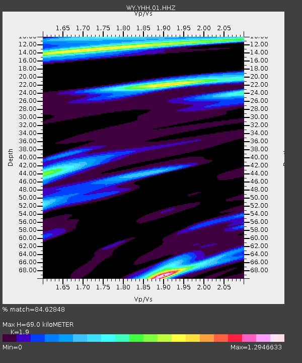
| Estimated Moho Depth: |
69.0 km |
| Estimated Crust Vp/Vs: |
1.90 |
| Assumed Crust Vp: |
6.35 km/s |
| Estimated Crust Vs: |
3.342 km/s |
| Estimated Crust Poisson's Ratio: |
0.31 |
|
| Radial Match: |
84.62848 % |
| Radial Bump: |
392 |
| Transverse Match: |
72.602104 % |
| Transverse Bump: |
400 |
| SOD ConfigId: |
18369291 |
| Insert Time: |
2019-06-30 05:30:03.137 +0000 |
| GWidth: |
2.5 |
| Max Bumps: |
400 |
| Tol: |
0.001 |
|
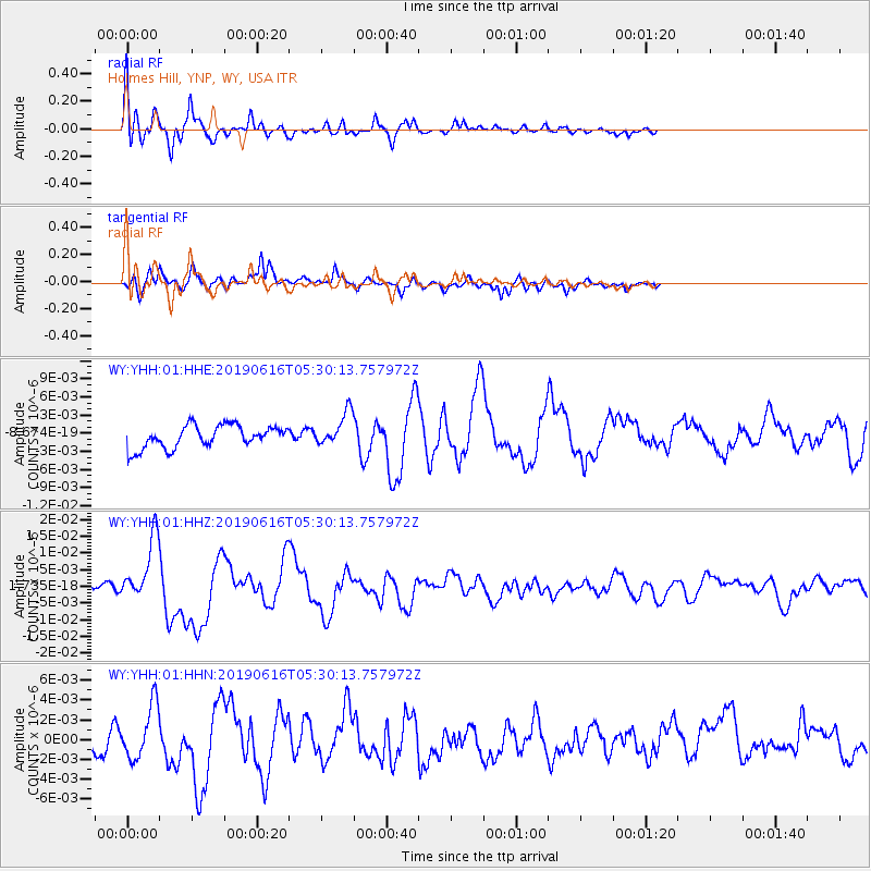
Signal To Noise
| Channel | StoN | STA | LTA |
| WY:YHH:01:HHZ:20190616T05:30:13.757972Z | 6.769291 | 9.5039265E-9 | 1.4039766E-9 |
| WY:YHH:01:HHN:20190616T05:30:13.757972Z | 2.061746 | 2.6370257E-9 | 1.2790257E-9 |
| WY:YHH:01:HHE:20190616T05:30:13.757972Z | 1.4669379 | 2.77276E-9 | 1.8901687E-9 |
| Arrivals |
| Ps | 10.0 SECOND |
| PpPs | 31 SECOND |
| PsPs/PpSs | 41 SECOND |


