You are here: Home > Network List > YN10 - San Jacinto Fault Zone Stations List
> Station RHIL RHIL > Earthquake Result Viewer
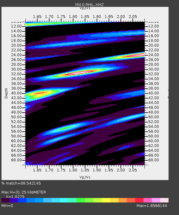
RHIL RHIL - Earthquake Result Viewer
| Earthquake location: |
Kermadec Islands Region |
| Earthquake latitude/longitude: |
-31.1/-178.0 |
| Earthquake time(UTC): |
2019/06/16 (167) 05:17:16 GMT |
| Earthquake Depth: |
35 km |
| Earthquake Magnitude: |
6.3 Mww |
| Earthquake Catalog/Contributor: |
NEIC PDE/us |
|
| Network: |
YN San Jacinto Fault Zone |
| Station: |
RHIL RHIL |
| Lat/Lon: |
33.67 N/116.77 W |
| Elevation: |
1557 m |
|
| Distance: |
86.5 deg |
| Az: |
47.096 deg |
| Baz: |
228.917 deg |
| Ray Param: |
0.04395195 |
| Estimated Moho Depth: |
31.25 km |
| Estimated Crust Vp/Vs: |
1.83 |
| Assumed Crust Vp: |
6.264 km/s |
| Estimated Crust Vs: |
3.427 km/s |
| Estimated Crust Poisson's Ratio: |
0.29 |
|
| Radial Match: |
89.542145 % |
| Radial Bump: |
400 |
| Transverse Match: |
82.12187 % |
| Transverse Bump: |
400 |
| SOD ConfigId: |
18369291 |
| Insert Time: |
2019-06-30 05:30:15.960 +0000 |
| GWidth: |
2.5 |
| Max Bumps: |
400 |
| Tol: |
0.001 |
|

Signal To Noise
| Channel | StoN | STA | LTA |
| YN:RHIL: :HHZ:20190616T05:29:24.839027Z | 9.617891 | 1.0016246E-6 | 1.04141805E-7 |
| YN:RHIL: :HHN:20190616T05:29:24.839027Z | 2.8974302 | 3.1261376E-7 | 1.07893456E-7 |
| YN:RHIL: :HHE:20190616T05:29:24.839027Z | 3.3502102 | 3.069159E-7 | 9.1610936E-8 |
| Arrivals |
| Ps | 4.2 SECOND |
| PpPs | 14 SECOND |
| PsPs/PpSs | 18 SECOND |


