You are here: Home > Network List > ZW13 - Locating North Texas Earthquakes Stations List
> Station IFDF Dallas Firestation > Earthquake Result Viewer
IFDF Dallas Firestation - Earthquake Result Viewer
| Earthquake location: |
San Juan Province, Argentina |
| Earthquake latitude/longitude: |
-31.6/-68.8 |
| Earthquake time(UTC): |
2016/11/20 (325) 20:57:43 GMT |
| Earthquake Depth: |
116 km |
| Earthquake Magnitude: |
6.4 MWP, 6.5 MWB |
| Earthquake Catalog/Contributor: |
NEIC PDE/NEIC COMCAT |
|
| Network: |
ZW Locating North Texas Earthquakes |
| Station: |
IFDF Dallas Firestation |
| Lat/Lon: |
32.78 N/96.90 W |
| Elevation: |
130 m |
|
| Distance: |
69.4 deg |
| Az: |
334.878 deg |
| Baz: |
154.545 deg |
| Ray Param: |
0.05538896 |
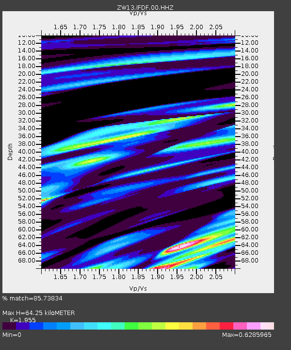
| Estimated Moho Depth: |
64.25 km |
| Estimated Crust Vp/Vs: |
1.96 |
| Assumed Crust Vp: |
6.38 km/s |
| Estimated Crust Vs: |
3.264 km/s |
| Estimated Crust Poisson's Ratio: |
0.32 |
|
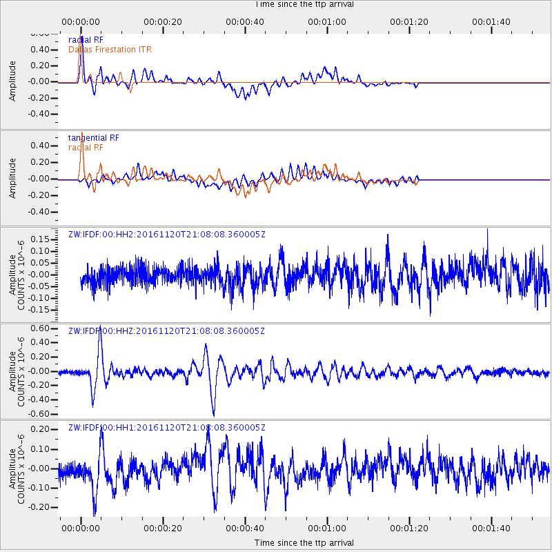
| Radial Match: |
85.73834 % |
| Radial Bump: |
400 |
| Transverse Match: |
79.09295 % |
| Transverse Bump: |
400 |
| SOD ConfigId: |
1858631 |
| Insert Time: |
2016-12-04 21:07:08.776 +0000 |
| GWidth: |
2.5 |
| Max Bumps: |
400 |
| Tol: |
0.001 |
|
Signal To Noise
| Channel | StoN | STA | LTA |
| ZW:IFDF:00:HHZ:20161120T21:08:08.360005Z | 16.079073 | 2.392557E-7 | 1.4879944E-8 |
| ZW:IFDF:00:HH1:20161120T21:08:08.360005Z | 3.393985 | 9.806379E-8 | 2.8893409E-8 |
| ZW:IFDF:00:HH2:20161120T21:08:08.360005Z | 1.0248815 | 3.3668133E-8 | 3.2850757E-8 |
| Arrivals |
| Ps | 9.9 SECOND |
| PpPs | 29 SECOND |
| PsPs/PpSs | 39 SECOND |


