You are here: Home > Network List > TA - USArray Transportable Network (new EarthScope stations) Stations List
> Station A21A Bergtoll Ranch, Theony, MT, USA > Earthquake Result Viewer
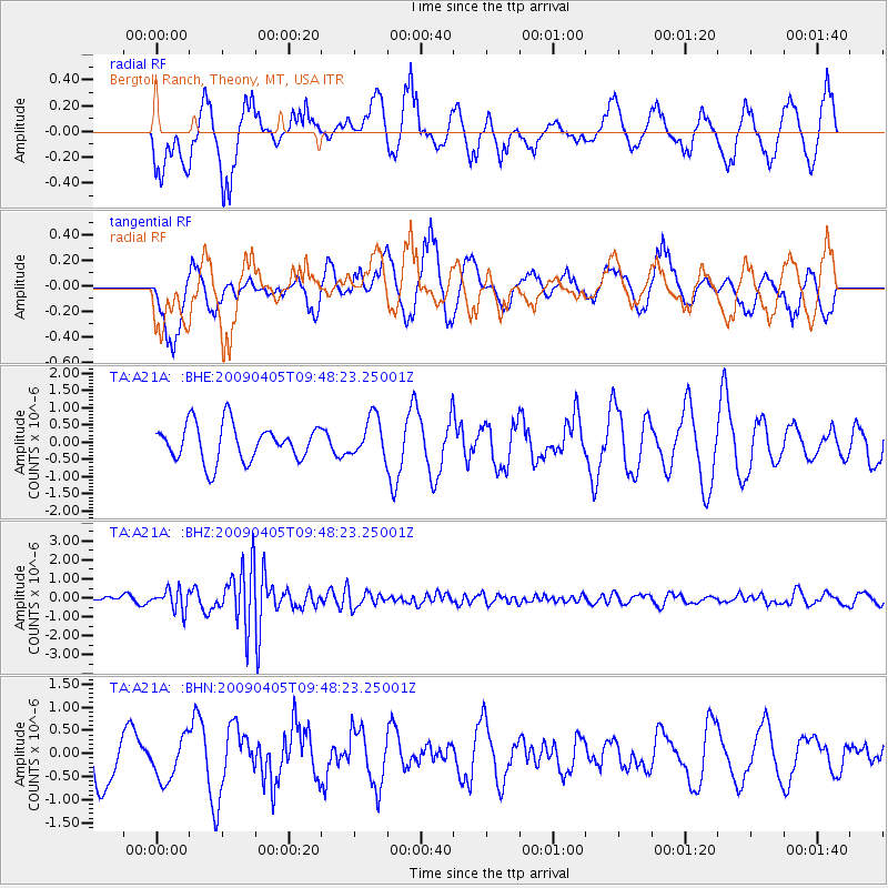
A21A Bergtoll Ranch, Theony, MT, USA - Earthquake Result Viewer
*The percent match for this event was below the threshold and hence no stack was calculated.
| Earthquake location: |
Kyushu, Japan |
| Earthquake latitude/longitude: |
32.0/131.4 |
| Earthquake time(UTC): |
2009/04/05 (095) 09:36:26 GMT |
| Earthquake Depth: |
26 km |
| Earthquake Magnitude: |
5.8 MB, 5.4 MS, 5.8 MW, 5.8 MW |
| Earthquake Catalog/Contributor: |
WHDF/NEIC |
|
| Network: |
TA USArray Transportable Network (new EarthScope stations) |
| Station: |
A21A Bergtoll Ranch, Theony, MT, USA |
| Lat/Lon: |
48.99 N/106.93 W |
| Elevation: |
779 m |
|
| Distance: |
84.1 deg |
| Az: |
34.311 deg |
| Baz: |
313.361 deg |
| Ray Param: |
$rayparam |
*The percent match for this event was below the threshold and hence was not used in the summary stack. |
|
| Radial Match: |
69.61719 % |
| Radial Bump: |
378 |
| Transverse Match: |
64.21824 % |
| Transverse Bump: |
400 |
| SOD ConfigId: |
2658 |
| Insert Time: |
2010-03-06 23:52:54.656 +0000 |
| GWidth: |
2.5 |
| Max Bumps: |
400 |
| Tol: |
0.001 |
|
Signal To Noise
| Channel | StoN | STA | LTA |
| TA:A21A: :BHZ:20090405T09:48:23.25001Z | 2.3732185 | 5.58017E-7 | 2.351309E-7 |
| TA:A21A: :BHN:20090405T09:48:23.25001Z | 0.7333933 | 4.540553E-7 | 6.191157E-7 |
| TA:A21A: :BHE:20090405T09:48:23.25001Z | 1.0844295 | 5.7510505E-7 | 5.3032954E-7 |
| Arrivals |
| Ps | |
| PpPs | |
| PsPs/PpSs | |


