You are here: Home > Network List > TA - USArray Transportable Network (new EarthScope stations) Stations List
> Station A21A Bergtoll Ranch, Theony, MT, USA > Earthquake Result Viewer
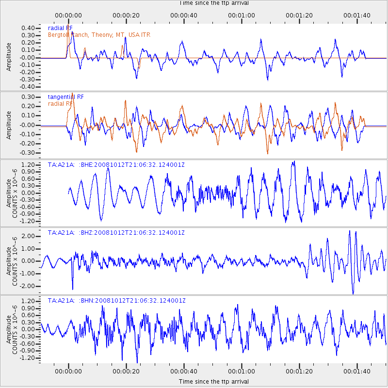
A21A Bergtoll Ranch, Theony, MT, USA - Earthquake Result Viewer
*The percent match for this event was below the threshold and hence no stack was calculated.
| Earthquake location: |
Southern Bolivia |
| Earthquake latitude/longitude: |
-20.1/-65.0 |
| Earthquake time(UTC): |
2008/10/12 (286) 20:55:41 GMT |
| Earthquake Depth: |
353 km |
| Earthquake Magnitude: |
6.0 MB, 6.2 MW, 6.2 MW |
| Earthquake Catalog/Contributor: |
WHDF/NEIC |
|
| Network: |
TA USArray Transportable Network (new EarthScope stations) |
| Station: |
A21A Bergtoll Ranch, Theony, MT, USA |
| Lat/Lon: |
48.99 N/106.93 W |
| Elevation: |
779 m |
|
| Distance: |
78.3 deg |
| Az: |
333.275 deg |
| Baz: |
140.09 deg |
| Ray Param: |
$rayparam |
*The percent match for this event was below the threshold and hence was not used in the summary stack. |
|
| Radial Match: |
57.953117 % |
| Radial Bump: |
400 |
| Transverse Match: |
44.87635 % |
| Transverse Bump: |
284 |
| SOD ConfigId: |
2556 |
| Insert Time: |
2010-03-06 23:53:01.850 +0000 |
| GWidth: |
2.5 |
| Max Bumps: |
400 |
| Tol: |
0.001 |
|
Signal To Noise
| Channel | StoN | STA | LTA |
| TA:A21A: :BHZ:20081012T21:06:32.124001Z | 2.7942252 | 6.00727E-7 | 2.1498875E-7 |
| TA:A21A: :BHN:20081012T21:06:32.124001Z | 1.1495848 | 2.5990263E-7 | 2.2608391E-7 |
| TA:A21A: :BHE:20081012T21:06:32.124001Z | 1.2113252 | 5.593337E-7 | 4.6175356E-7 |
| Arrivals |
| Ps | |
| PpPs | |
| PsPs/PpSs | |


