You are here: Home > Network List > TA - USArray Transportable Network (new EarthScope stations) Stations List
> Station A21A Bergtoll Ranch, Theony, MT, USA > Earthquake Result Viewer
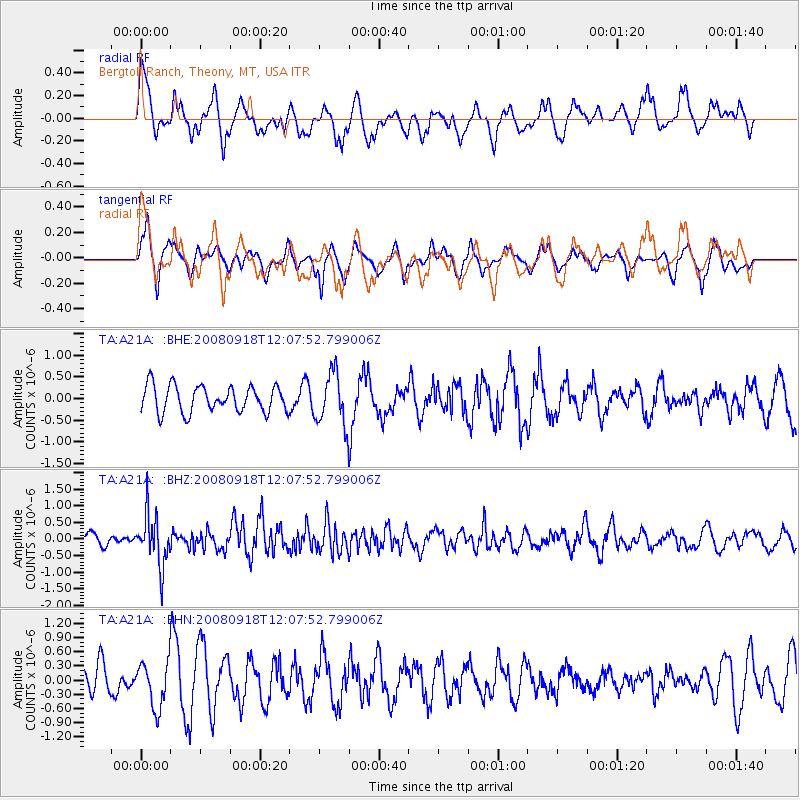
A21A Bergtoll Ranch, Theony, MT, USA - Earthquake Result Viewer
*The percent match for this event was below the threshold and hence no stack was calculated.
| Earthquake location: |
Near East Coast Of Kamchatka |
| Earthquake latitude/longitude: |
51.9/158.4 |
| Earthquake time(UTC): |
2008/09/18 (262) 11:58:50 GMT |
| Earthquake Depth: |
67 km |
| Earthquake Magnitude: |
5.7 MB, 5.9 MW, 5.8 MW |
| Earthquake Catalog/Contributor: |
WHDF/NEIC |
|
| Network: |
TA USArray Transportable Network (new EarthScope stations) |
| Station: |
A21A Bergtoll Ranch, Theony, MT, USA |
| Lat/Lon: |
48.99 N/106.93 W |
| Elevation: |
779 m |
|
| Distance: |
56.1 deg |
| Az: |
52.252 deg |
| Baz: |
311.973 deg |
| Ray Param: |
$rayparam |
*The percent match for this event was below the threshold and hence was not used in the summary stack. |
|
| Radial Match: |
61.799652 % |
| Radial Bump: |
400 |
| Transverse Match: |
55.28441 % |
| Transverse Bump: |
351 |
| SOD ConfigId: |
2560 |
| Insert Time: |
2010-03-06 23:53:06.154 +0000 |
| GWidth: |
2.5 |
| Max Bumps: |
400 |
| Tol: |
0.001 |
|
Signal To Noise
| Channel | StoN | STA | LTA |
| TA:A21A: :BHZ:20080918T12:07:52.799006Z | 4.9716716 | 7.6737854E-7 | 1.543502E-7 |
| TA:A21A: :BHN:20080918T12:07:52.799006Z | 1.6226172 | 4.803411E-7 | 2.960286E-7 |
| TA:A21A: :BHE:20080918T12:07:52.799006Z | 1.9744334 | 5.9968977E-7 | 3.0372752E-7 |
| Arrivals |
| Ps | |
| PpPs | |
| PsPs/PpSs | |


