You are here: Home > Network List > TA - USArray Transportable Network (new EarthScope stations) Stations List
> Station D24A Glendive, MT, USA > Earthquake Result Viewer
D24A Glendive, MT, USA - Earthquake Result Viewer
| Earthquake location: |
Kuril Islands |
| Earthquake latitude/longitude: |
46.0/151.5 |
| Earthquake time(UTC): |
2009/04/07 (097) 04:23:33 GMT |
| Earthquake Depth: |
31 km |
| Earthquake Magnitude: |
6.5 MB, 6.8 MS, 6.9 MW, 6.9 MW |
| Earthquake Catalog/Contributor: |
WHDF/NEIC |
|
| Network: |
TA USArray Transportable Network (new EarthScope stations) |
| Station: |
D24A Glendive, MT, USA |
| Lat/Lon: |
47.12 N/104.33 W |
| Elevation: |
766 m |
|
| Distance: |
65.9 deg |
| Az: |
46.509 deg |
| Baz: |
312.285 deg |
| Ray Param: |
0.057910588 |
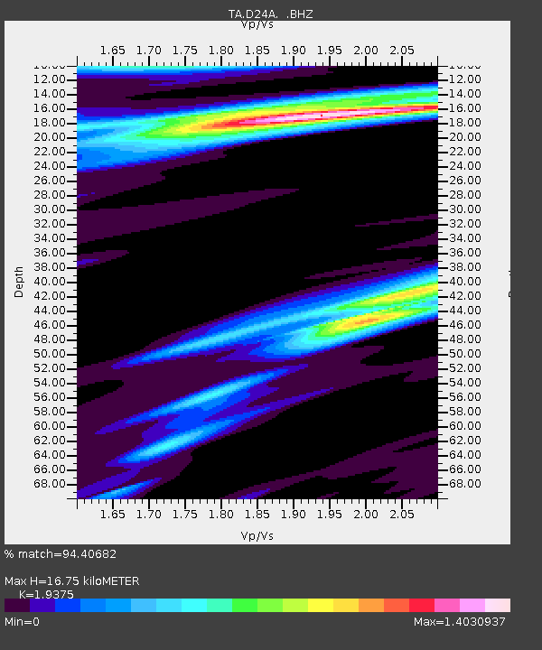
| Estimated Moho Depth: |
16.75 km |
| Estimated Crust Vp/Vs: |
1.94 |
| Assumed Crust Vp: |
6.438 km/s |
| Estimated Crust Vs: |
3.323 km/s |
| Estimated Crust Poisson's Ratio: |
0.32 |
|
| Radial Match: |
94.40682 % |
| Radial Bump: |
282 |
| Transverse Match: |
77.37274 % |
| Transverse Bump: |
400 |
| SOD ConfigId: |
2658 |
| Insert Time: |
2010-03-06 23:53:34.603 +0000 |
| GWidth: |
2.5 |
| Max Bumps: |
400 |
| Tol: |
0.001 |
|
Signal To Noise
| Channel | StoN | STA | LTA |
| TA:D24A: :BHZ:20090407T04:33:45.150Z | 22.007591 | 6.4266246E-6 | 2.9201854E-7 |
| TA:D24A: :BHN:20090407T04:33:45.150Z | 3.5234137 | 1.80697E-6 | 5.128464E-7 |
| TA:D24A: :BHE:20090407T04:33:45.150Z | 4.598798 | 2.035686E-6 | 4.4265616E-7 |
| Arrivals |
| Ps | 2.5 SECOND |
| PpPs | 7.4 SECOND |
| PsPs/PpSs | 9.9 SECOND |


