You are here: Home > Network List > TA - USArray Transportable Network (new EarthScope stations) Stations List
> Station E20K Nigu River, AK, USA > Earthquake Result Viewer
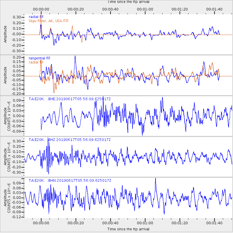
E20K Nigu River, AK, USA - Earthquake Result Viewer
*The percent match for this event was below the threshold and hence no stack was calculated.
| Earthquake location: |
Flores Region, Indonesia |
| Earthquake latitude/longitude: |
-8.8/123.0 |
| Earthquake time(UTC): |
2019/06/17 (168) 05:43:31 GMT |
| Earthquake Depth: |
109 km |
| Earthquake Magnitude: |
5.5 Mww |
| Earthquake Catalog/Contributor: |
NEIC PDE/us |
|
| Network: |
TA USArray Transportable Network (new EarthScope stations) |
| Station: |
E20K Nigu River, AK, USA |
| Lat/Lon: |
68.26 N/156.19 W |
| Elevation: |
866 m |
|
| Distance: |
94.7 deg |
| Az: |
21.656 deg |
| Baz: |
258.191 deg |
| Ray Param: |
$rayparam |
*The percent match for this event was below the threshold and hence was not used in the summary stack. |
|
| Radial Match: |
42.165535 % |
| Radial Bump: |
400 |
| Transverse Match: |
39.287933 % |
| Transverse Bump: |
400 |
| SOD ConfigId: |
18369291 |
| Insert Time: |
2019-07-01 05:45:31.039 +0000 |
| GWidth: |
2.5 |
| Max Bumps: |
400 |
| Tol: |
0.001 |
|
Signal To Noise
| Channel | StoN | STA | LTA |
| TA:E20K: :BHZ:20190617T05:56:09.625017Z | 3.2820978 | 1.4948836E-7 | 4.554659E-8 |
| TA:E20K: :BHN:20190617T05:56:09.625017Z | 1.1556592 | 4.34194E-8 | 3.7571112E-8 |
| TA:E20K: :BHE:20190617T05:56:09.625017Z | 1.480032 | 4.8709875E-8 | 3.2911366E-8 |
| Arrivals |
| Ps | |
| PpPs | |
| PsPs/PpSs | |


