You are here: Home > Network List > TA - USArray Transportable Network (new EarthScope stations) Stations List
> Station D24A Glendive, MT, USA > Earthquake Result Viewer
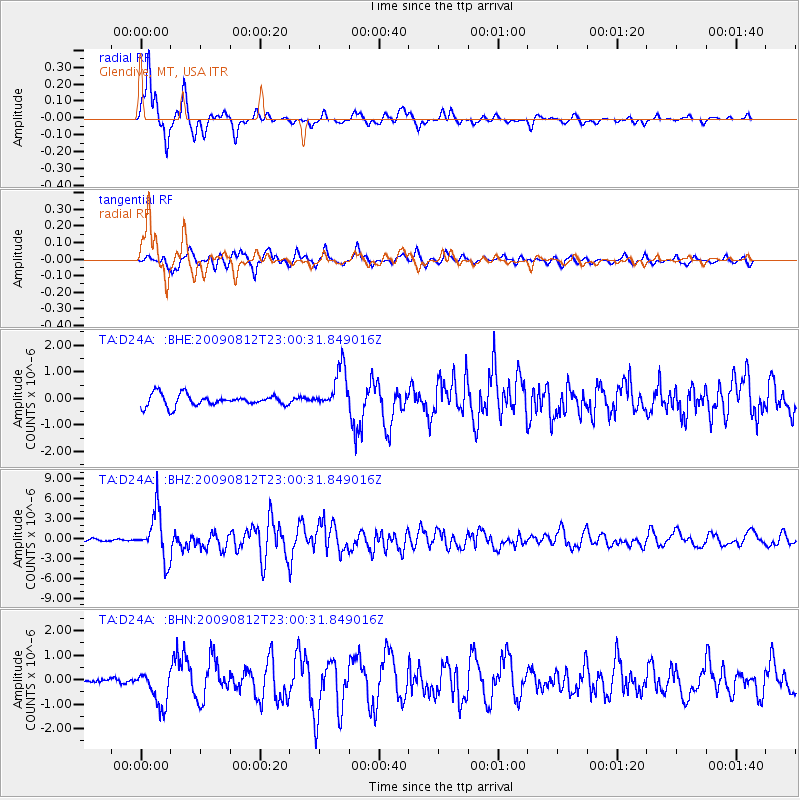
D24A Glendive, MT, USA - Earthquake Result Viewer
*The percent match for this event was below the threshold and hence no stack was calculated.
| Earthquake location: |
Southeast Of Honshu, Japan |
| Earthquake latitude/longitude: |
32.8/140.4 |
| Earthquake time(UTC): |
2009/08/12 (224) 22:48:51 GMT |
| Earthquake Depth: |
53 km |
| Earthquake Magnitude: |
6.2 MB, 6.6 MW, 6.6 MW |
| Earthquake Catalog/Contributor: |
WHDF/NEIC |
|
| Network: |
TA USArray Transportable Network (new EarthScope stations) |
| Station: |
D24A Glendive, MT, USA |
| Lat/Lon: |
47.12 N/104.33 W |
| Elevation: |
766 m |
|
| Distance: |
81.5 deg |
| Az: |
38.646 deg |
| Baz: |
309.653 deg |
| Ray Param: |
$rayparam |
*The percent match for this event was below the threshold and hence was not used in the summary stack. |
|
| Radial Match: |
93.226425 % |
| Radial Bump: |
317 |
| Transverse Match: |
91.0804 % |
| Transverse Bump: |
400 |
| SOD ConfigId: |
2622 |
| Insert Time: |
2010-03-06 23:53:51.301 +0000 |
| GWidth: |
2.5 |
| Max Bumps: |
400 |
| Tol: |
0.001 |
|
Signal To Noise
| Channel | StoN | STA | LTA |
| TA:D24A: :BHZ:20090812T23:00:31.849016Z | 21.077374 | 3.530566E-6 | 1.6750502E-7 |
| TA:D24A: :BHN:20090812T23:00:31.849016Z | 4.454546 | 7.2258274E-7 | 1.6221243E-7 |
| TA:D24A: :BHE:20090812T23:00:31.849016Z | 3.5658622 | 7.7315457E-7 | 2.1682122E-7 |
| Arrivals |
| Ps | |
| PpPs | |
| PsPs/PpSs | |


