You are here: Home > Network List > TA - USArray Transportable Network (new EarthScope stations) Stations List
> Station D24A Glendive, MT, USA > Earthquake Result Viewer
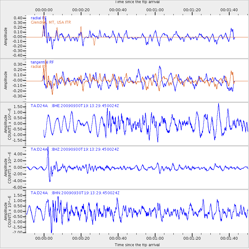
D24A Glendive, MT, USA - Earthquake Result Viewer
*The percent match for this event was below the threshold and hence no stack was calculated.
| Earthquake location: |
Peru-Bolivia Border Region |
| Earthquake latitude/longitude: |
-15.6/-69.3 |
| Earthquake time(UTC): |
2009/09/30 (273) 19:03:17 GMT |
| Earthquake Depth: |
255 km |
| Earthquake Magnitude: |
5.9 MB, 5.8 MW |
| Earthquake Catalog/Contributor: |
WHDF/NEIC |
|
| Network: |
TA USArray Transportable Network (new EarthScope stations) |
| Station: |
D24A Glendive, MT, USA |
| Lat/Lon: |
47.12 N/104.33 W |
| Elevation: |
766 m |
|
| Distance: |
69.9 deg |
| Az: |
335.315 deg |
| Baz: |
143.888 deg |
| Ray Param: |
$rayparam |
*The percent match for this event was below the threshold and hence was not used in the summary stack. |
|
| Radial Match: |
59.313667 % |
| Radial Bump: |
400 |
| Transverse Match: |
53.909245 % |
| Transverse Bump: |
400 |
| SOD ConfigId: |
2622 |
| Insert Time: |
2010-03-06 23:54:06.765 +0000 |
| GWidth: |
2.5 |
| Max Bumps: |
400 |
| Tol: |
0.001 |
|
Signal To Noise
| Channel | StoN | STA | LTA |
| TA:D24A: :BHZ:20090930T19:13:29.450024Z | 8.93113 | 2.2069758E-6 | 2.4711048E-7 |
| TA:D24A: :BHN:20090930T19:13:29.450024Z | 2.8435757 | 8.3740633E-7 | 2.944906E-7 |
| TA:D24A: :BHE:20090930T19:13:29.450024Z | 1.296056 | 6.7719765E-7 | 5.2250647E-7 |
| Arrivals |
| Ps | |
| PpPs | |
| PsPs/PpSs | |


