You are here: Home > Network List > TA - USArray Transportable Network (new EarthScope stations) Stations List
> Station D24A Glendive, MT, USA > Earthquake Result Viewer
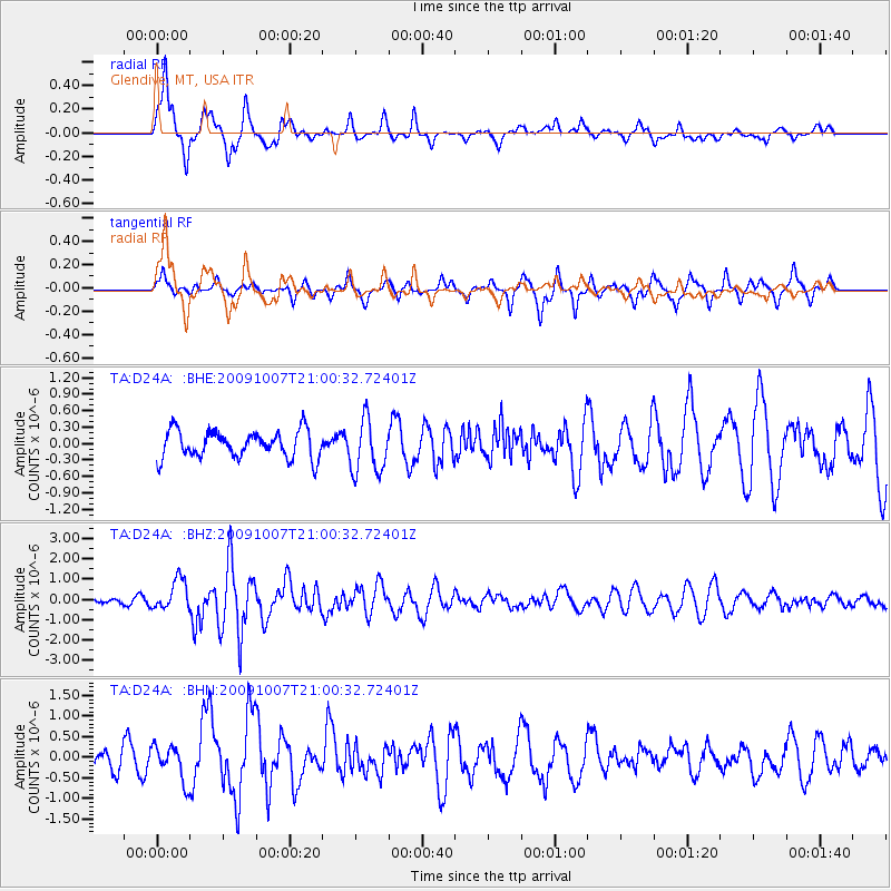
D24A Glendive, MT, USA - Earthquake Result Viewer
*The percent match for this event was below the threshold and hence no stack was calculated.
| Earthquake location: |
East Of Severnaya Zemlya |
| Earthquake latitude/longitude: |
81.6/119.5 |
| Earthquake time(UTC): |
2009/10/07 (280) 20:52:13 GMT |
| Earthquake Depth: |
8.0 km |
| Earthquake Magnitude: |
5.7 MB, 5.1 MS, 5.8 MW, 5.8 MW |
| Earthquake Catalog/Contributor: |
WHDF/NEIC |
|
| Network: |
TA USArray Transportable Network (new EarthScope stations) |
| Station: |
D24A Glendive, MT, USA |
| Lat/Lon: |
47.12 N/104.33 W |
| Elevation: |
766 m |
|
| Distance: |
49.5 deg |
| Az: |
38.505 deg |
| Baz: |
352.271 deg |
| Ray Param: |
$rayparam |
*The percent match for this event was below the threshold and hence was not used in the summary stack. |
|
| Radial Match: |
80.784386 % |
| Radial Bump: |
400 |
| Transverse Match: |
69.121605 % |
| Transverse Bump: |
327 |
| SOD ConfigId: |
2622 |
| Insert Time: |
2010-03-06 23:54:08.168 +0000 |
| GWidth: |
2.5 |
| Max Bumps: |
400 |
| Tol: |
0.001 |
|
Signal To Noise
| Channel | StoN | STA | LTA |
| TA:D24A: :BHZ:20091007T21:00:32.72401Z | 4.40467 | 7.559727E-7 | 1.7162982E-7 |
| TA:D24A: :BHN:20091007T21:00:32.72401Z | 1.8459766 | 4.1843666E-7 | 2.2667496E-7 |
| TA:D24A: :BHE:20091007T21:00:32.72401Z | 1.9774281 | 4.8935294E-7 | 2.4746942E-7 |
| Arrivals |
| Ps | |
| PpPs | |
| PsPs/PpSs | |


