You are here: Home > Network List > GS - US Geological Survey Networks Stations List
> Station DEC05 Decatur Surface Seismic Site, Decatur, IL, USA > Earthquake Result Viewer
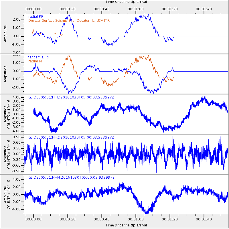
DEC05 Decatur Surface Seismic Site, Decatur, IL, USA - Earthquake Result Viewer
*The percent match for this event was below the threshold and hence no stack was calculated.
| Earthquake location: |
Near Coast Of Northern Chile |
| Earthquake latitude/longitude: |
-25.2/-70.4 |
| Earthquake time(UTC): |
2016/10/30 (304) 04:49:40 GMT |
| Earthquake Depth: |
0.0 km |
| Earthquake Magnitude: |
5.2 |
| Earthquake Catalog/Contributor: |
NEIC PDE/us |
|
| Network: |
GS US Geological Survey Networks |
| Station: |
DEC05 Decatur Surface Seismic Site, Decatur, IL, USA |
| Lat/Lon: |
39.87 N/88.87 W |
| Elevation: |
216 m |
|
| Distance: |
67.0 deg |
| Az: |
344.655 deg |
| Baz: |
161.846 deg |
| Ray Param: |
$rayparam |
*The percent match for this event was below the threshold and hence was not used in the summary stack. |
|
| Radial Match: |
19.723331 % |
| Radial Bump: |
400 |
| Transverse Match: |
20.463362 % |
| Transverse Bump: |
400 |
| SOD ConfigId: |
1858631 |
| Insert Time: |
2016-12-05 19:07:54.678 +0000 |
| GWidth: |
2.5 |
| Max Bumps: |
400 |
| Tol: |
0.001 |
|
Signal To Noise
| Channel | StoN | STA | LTA |
| GS:DEC05:01:HHZ:20161030T05:00:03.933997Z | 0.6459837 | 2.9998932E-7 | 4.643915E-7 |
| GS:DEC05:01:HHN:20161030T05:00:03.933997Z | 2.2294378 | 2.10461E-6 | 9.4400934E-7 |
| GS:DEC05:01:HHE:20161030T05:00:03.933997Z | 0.3640452 | 6.0446206E-7 | 1.6604039E-6 |
| Arrivals |
| Ps | |
| PpPs | |
| PsPs/PpSs | |


