You are here: Home > Network List > TA - USArray Transportable Network (new EarthScope stations) Stations List
> Station D24A Glendive, MT, USA > Earthquake Result Viewer
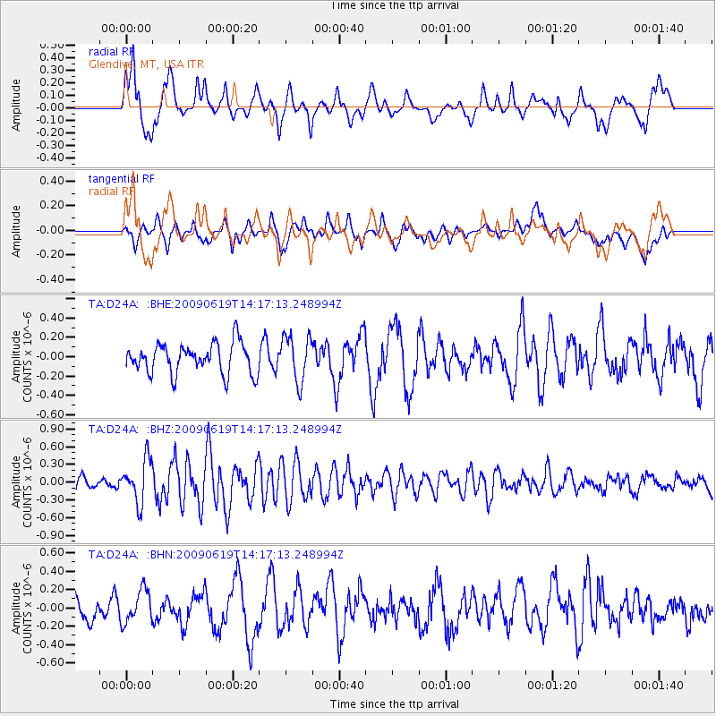
D24A Glendive, MT, USA - Earthquake Result Viewer
*The percent match for this event was below the threshold and hence no stack was calculated.
| Earthquake location: |
Eastern Mediterranean Sea |
| Earthquake latitude/longitude: |
35.4/28.5 |
| Earthquake time(UTC): |
2009/06/19 (170) 14:04:59 GMT |
| Earthquake Depth: |
28 km |
| Earthquake Magnitude: |
5.6 MB, 5.6 MS, 5.8 MW, 5.8 MW |
| Earthquake Catalog/Contributor: |
WHDF/NEIC |
|
| Network: |
TA USArray Transportable Network (new EarthScope stations) |
| Station: |
D24A Glendive, MT, USA |
| Lat/Lon: |
47.12 N/104.33 W |
| Elevation: |
766 m |
|
| Distance: |
87.6 deg |
| Az: |
329.886 deg |
| Baz: |
36.902 deg |
| Ray Param: |
$rayparam |
*The percent match for this event was below the threshold and hence was not used in the summary stack. |
|
| Radial Match: |
68.19345 % |
| Radial Bump: |
400 |
| Transverse Match: |
53.385994 % |
| Transverse Bump: |
400 |
| SOD ConfigId: |
2648 |
| Insert Time: |
2010-03-06 23:54:39.681 +0000 |
| GWidth: |
2.5 |
| Max Bumps: |
400 |
| Tol: |
0.001 |
|
Signal To Noise
| Channel | StoN | STA | LTA |
| TA:D24A: :BHZ:20090619T14:17:13.248994Z | 2.9313176 | 3.7011816E-7 | 1.2626342E-7 |
| TA:D24A: :BHN:20090619T14:17:13.248994Z | 1.3185241 | 1.7954792E-7 | 1.3617341E-7 |
| TA:D24A: :BHE:20090619T14:17:13.248994Z | 1.5318499 | 2.374726E-7 | 1.5502343E-7 |
| Arrivals |
| Ps | |
| PpPs | |
| PsPs/PpSs | |


