You are here: Home > Network List > CI - Caltech Regional Seismic Network Stations List
> Station DAN Danby, California, USA > Earthquake Result Viewer
DAN Danby, California, USA - Earthquake Result Viewer
| Earthquake location: |
Kermadec Islands, New Zealand |
| Earthquake latitude/longitude: |
-30.9/-177.6 |
| Earthquake time(UTC): |
2019/06/17 (168) 06:02:05 GMT |
| Earthquake Depth: |
16 km |
| Earthquake Magnitude: |
6.0 Mww |
| Earthquake Catalog/Contributor: |
NEIC PDE/us |
|
| Network: |
CI Caltech Regional Seismic Network |
| Station: |
DAN Danby, California, USA |
| Lat/Lon: |
34.64 N/115.38 W |
| Elevation: |
398 m |
|
| Distance: |
87.7 deg |
| Az: |
46.895 deg |
| Baz: |
229.536 deg |
| Ray Param: |
0.043153305 |
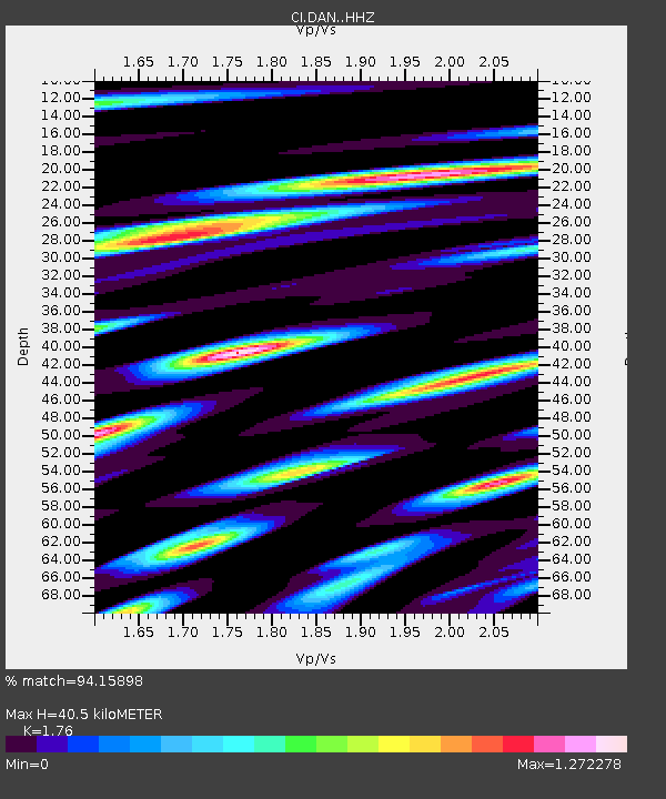
| Estimated Moho Depth: |
40.5 km |
| Estimated Crust Vp/Vs: |
1.76 |
| Assumed Crust Vp: |
6.276 km/s |
| Estimated Crust Vs: |
3.566 km/s |
| Estimated Crust Poisson's Ratio: |
0.26 |
|
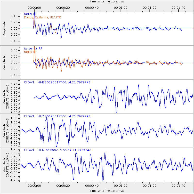
| Radial Match: |
94.15898 % |
| Radial Bump: |
400 |
| Transverse Match: |
85.70006 % |
| Transverse Bump: |
400 |
| SOD ConfigId: |
18369291 |
| Insert Time: |
2019-07-01 06:04:45.777 +0000 |
| GWidth: |
2.5 |
| Max Bumps: |
400 |
| Tol: |
0.001 |
|
Signal To Noise
| Channel | StoN | STA | LTA |
| CI:DAN: :HHZ:20190617T06:14:21.797974Z | 4.827432 | 3.8891628E-7 | 8.056381E-8 |
| CI:DAN: :HHN:20190617T06:14:21.797974Z | 1.9277756 | 1.854785E-7 | 9.621374E-8 |
| CI:DAN: :HHE:20190617T06:14:21.797974Z | 1.4796302 | 1.4872386E-7 | 1.0051421E-7 |
| Arrivals |
| Ps | 5.0 SECOND |
| PpPs | 17 SECOND |
| PsPs/PpSs | 22 SECOND |


