You are here: Home > Network List > CI - Caltech Regional Seismic Network Stations List
> Station FMP Fort MacArthur Park, Pt. Fermin San Pedro, CA, USA > Earthquake Result Viewer
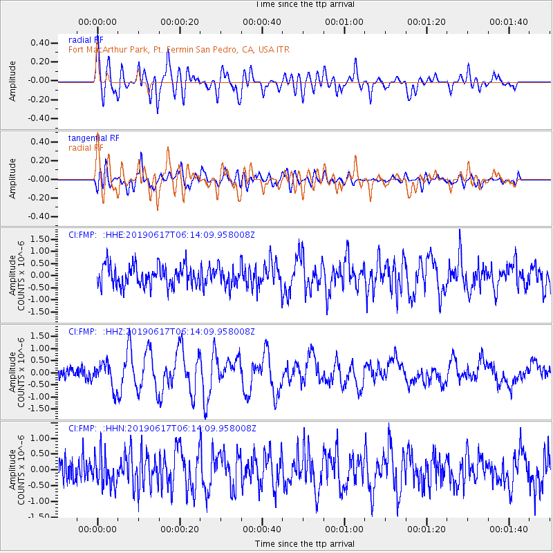
FMP Fort MacArthur Park, Pt. Fermin San Pedro, CA, USA - Earthquake Result Viewer
| Earthquake location: |
Kermadec Islands, New Zealand |
| Earthquake latitude/longitude: |
-30.9/-177.6 |
| Earthquake time(UTC): |
2019/06/17 (168) 06:02:05 GMT |
| Earthquake Depth: |
16 km |
| Earthquake Magnitude: |
6.0 Mww |
| Earthquake Catalog/Contributor: |
NEIC PDE/us |
|
| Network: |
CI Caltech Regional Seismic Network |
| Station: |
FMP Fort MacArthur Park, Pt. Fermin San Pedro, CA, USA |
| Lat/Lon: |
33.71 N/118.29 W |
| Elevation: |
89 m |
|
| Distance: |
85.2 deg |
| Az: |
45.991 deg |
| Baz: |
227.851 deg |
| Ray Param: |
0.044896998 |
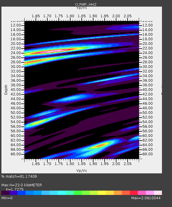
| Estimated Moho Depth: |
23.0 km |
| Estimated Crust Vp/Vs: |
1.73 |
| Assumed Crust Vp: |
6.048 km/s |
| Estimated Crust Vs: |
3.501 km/s |
| Estimated Crust Poisson's Ratio: |
0.25 |
|
| Radial Match: |
81.17409 % |
| Radial Bump: |
400 |
| Transverse Match: |
71.213974 % |
| Transverse Bump: |
400 |
| SOD ConfigId: |
18369291 |
| Insert Time: |
2019-07-01 06:04:49.227 +0000 |
| GWidth: |
2.5 |
| Max Bumps: |
400 |
| Tol: |
0.001 |
|
Signal To Noise
| Channel | StoN | STA | LTA |
| CI:FMP: :HHZ:20190617T06:14:09.958008Z | 2.2473147 | 5.2680286E-7 | 2.3441439E-7 |
| CI:FMP: :HHN:20190617T06:14:09.958008Z | 1.6928576 | 4.9998437E-7 | 2.9534934E-7 |
| CI:FMP: :HHE:20190617T06:14:09.958008Z | 0.9491585 | 3.981129E-7 | 4.1943773E-7 |
| Arrivals |
| Ps | 2.8 SECOND |
| PpPs | 10 SECOND |
| PsPs/PpSs | 13 SECOND |


