You are here: Home > Network List > CI - Caltech Regional Seismic Network Stations List
> Station GMR Granite Mountains Research Center > Earthquake Result Viewer
GMR Granite Mountains Research Center - Earthquake Result Viewer
| Earthquake location: |
Kermadec Islands, New Zealand |
| Earthquake latitude/longitude: |
-30.9/-177.6 |
| Earthquake time(UTC): |
2019/06/17 (168) 06:02:05 GMT |
| Earthquake Depth: |
16 km |
| Earthquake Magnitude: |
6.0 Mww |
| Earthquake Catalog/Contributor: |
NEIC PDE/us |
|
| Network: |
CI Caltech Regional Seismic Network |
| Station: |
GMR Granite Mountains Research Center |
| Lat/Lon: |
34.78 N/115.66 W |
| Elevation: |
1326 m |
|
| Distance: |
87.6 deg |
| Az: |
46.633 deg |
| Baz: |
229.367 deg |
| Ray Param: |
0.043212228 |
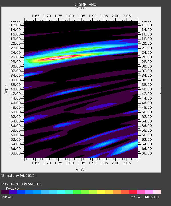
| Estimated Moho Depth: |
26.0 km |
| Estimated Crust Vp/Vs: |
1.75 |
| Assumed Crust Vp: |
6.276 km/s |
| Estimated Crust Vs: |
3.586 km/s |
| Estimated Crust Poisson's Ratio: |
0.26 |
|
| Radial Match: |
96.26124 % |
| Radial Bump: |
335 |
| Transverse Match: |
79.794685 % |
| Transverse Bump: |
400 |
| SOD ConfigId: |
18369291 |
| Insert Time: |
2019-07-01 06:04:50.740 +0000 |
| GWidth: |
2.5 |
| Max Bumps: |
400 |
| Tol: |
0.001 |
|

Signal To Noise
| Channel | StoN | STA | LTA |
| CI:GMR: :HHZ:20190617T06:14:21.427979Z | 5.067848 | 3.4253006E-7 | 6.758886E-8 |
| CI:GMR: :HHN:20190617T06:14:21.427979Z | 1.774235 | 8.6657515E-8 | 4.8842185E-8 |
| CI:GMR: :HHE:20190617T06:14:21.427979Z | 2.857529 | 1.0412821E-7 | 3.643995E-8 |
| Arrivals |
| Ps | 3.2 SECOND |
| PpPs | 11 SECOND |
| PsPs/PpSs | 14 SECOND |


