You are here: Home > Network List > TA - USArray Transportable Network (new EarthScope stations) Stations List
> Station D24A Glendive, MT, USA > Earthquake Result Viewer
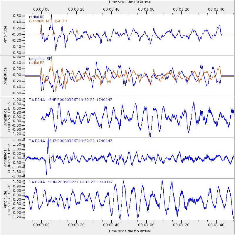
D24A Glendive, MT, USA - Earthquake Result Viewer
*The percent match for this event was below the threshold and hence no stack was calculated.
| Earthquake location: |
Northwest Of Ryukyu Islands |
| Earthquake latitude/longitude: |
27.4/126.7 |
| Earthquake time(UTC): |
2009/03/26 (085) 19:19:59 GMT |
| Earthquake Depth: |
160 km |
| Earthquake Magnitude: |
5.6 MB, 5.9 MW, 5.9 MW |
| Earthquake Catalog/Contributor: |
WHDF/NEIC |
|
| Network: |
TA USArray Transportable Network (new EarthScope stations) |
| Station: |
D24A Glendive, MT, USA |
| Lat/Lon: |
47.12 N/104.33 W |
| Elevation: |
766 m |
|
| Distance: |
92.7 deg |
| Az: |
32.113 deg |
| Baz: |
316.219 deg |
| Ray Param: |
$rayparam |
*The percent match for this event was below the threshold and hence was not used in the summary stack. |
|
| Radial Match: |
52.35113 % |
| Radial Bump: |
400 |
| Transverse Match: |
50.14289 % |
| Transverse Bump: |
400 |
| SOD ConfigId: |
2658 |
| Insert Time: |
2010-03-06 23:55:02.152 +0000 |
| GWidth: |
2.5 |
| Max Bumps: |
400 |
| Tol: |
0.001 |
|
Signal To Noise
| Channel | StoN | STA | LTA |
| TA:D24A: :BHZ:20090326T19:32:22.174014Z | 3.3706799 | 8.075122E-7 | 2.3956952E-7 |
| TA:D24A: :BHN:20090326T19:32:22.174014Z | 0.71805125 | 3.7608746E-7 | 5.237613E-7 |
| TA:D24A: :BHE:20090326T19:32:22.174014Z | 0.97729003 | 3.8095286E-7 | 3.898053E-7 |
| Arrivals |
| Ps | |
| PpPs | |
| PsPs/PpSs | |


