You are here: Home > Network List > TS - TERRAscope (Southern California Seismic Network) Stations List
> Station GSC Goldston, California, USA > Earthquake Result Viewer
GSC Goldston, California, USA - Earthquake Result Viewer
| Earthquake location: |
San Juan Province, Argentina |
| Earthquake latitude/longitude: |
-31.6/-69.2 |
| Earthquake time(UTC): |
1993/06/08 (159) 23:17:41 GMT |
| Earthquake Depth: |
113 km |
| Earthquake Magnitude: |
6.4 MB, 6.4 UNKNOWN |
| Earthquake Catalog/Contributor: |
WHDF/NEIC |
|
| Network: |
TS TERRAscope (Southern California Seismic Network) |
| Station: |
GSC Goldston, California, USA |
| Lat/Lon: |
35.30 N/116.81 W |
| Elevation: |
990 m |
|
| Distance: |
80.2 deg |
| Az: |
322.202 deg |
| Baz: |
140.252 deg |
| Ray Param: |
0.048207786 |
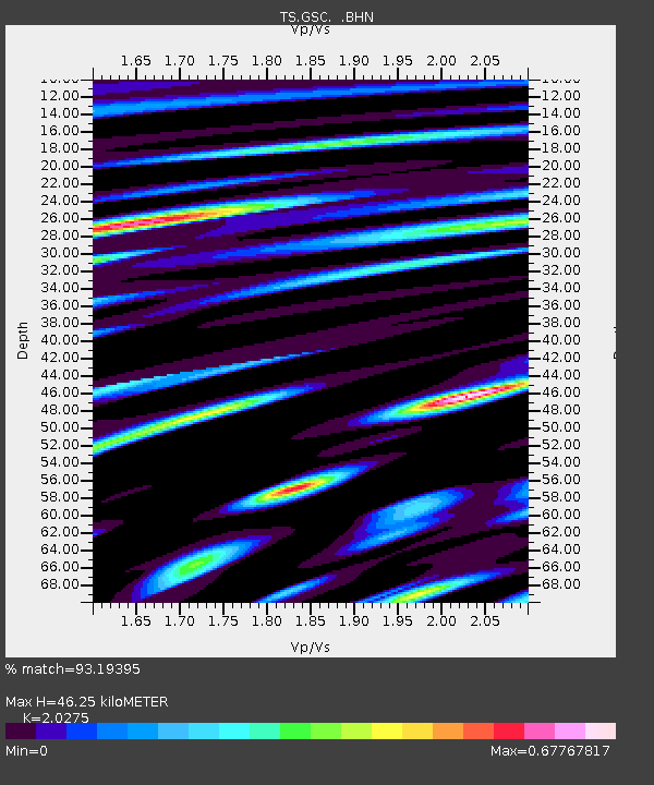
| Estimated Moho Depth: |
46.25 km |
| Estimated Crust Vp/Vs: |
2.03 |
| Assumed Crust Vp: |
6.276 km/s |
| Estimated Crust Vs: |
3.095 km/s |
| Estimated Crust Poisson's Ratio: |
0.34 |
|
| Radial Match: |
93.19395 % |
| Radial Bump: |
400 |
| Transverse Match: |
87.42126 % |
| Transverse Bump: |
400 |
| SOD ConfigId: |
16938 |
| Insert Time: |
2010-02-26 14:16:11.620 +0000 |
| GWidth: |
2.5 |
| Max Bumps: |
400 |
| Tol: |
0.001 |
|

Signal To Noise
| Channel | StoN | STA | LTA |
| TS:GSC: :BHN:19930608T23:29:08.129004Z | 3.4768121 | 4.4846828E-7 | 1.2898836E-7 |
| TS:GSC: :BHE:19930608T23:29:08.129004Z | 7.5659957 | 6.614678E-7 | 8.742641E-8 |
| TS:GSC: :BHZ:19930608T23:29:08.129004Z | 19.26749 | 2.251108E-6 | 1.1683452E-7 |
| Arrivals |
| Ps | 7.8 SECOND |
| PpPs | 22 SECOND |
| PsPs/PpSs | 30 SECOND |


