You are here: Home > Network List > TA - USArray Transportable Network (new EarthScope stations) Stations List
> Station D12A Red Ives Forest Station, Avery, ID, USA > Earthquake Result Viewer
D12A Red Ives Forest Station, Avery, ID, USA - Earthquake Result Viewer
| Earthquake location: |
Eastern Honshu, Japan |
| Earthquake latitude/longitude: |
39.8/141.5 |
| Earthquake time(UTC): |
2008/07/23 (205) 15:26:19 GMT |
| Earthquake Depth: |
108 km |
| Earthquake Magnitude: |
6.6 MB, 6.8 MW, 6.8 MW |
| Earthquake Catalog/Contributor: |
WHDF/NEIC |
|
| Network: |
TA USArray Transportable Network (new EarthScope stations) |
| Station: |
D12A Red Ives Forest Station, Avery, ID, USA |
| Lat/Lon: |
47.05 N/115.35 W |
| Elevation: |
1135 m |
|
| Distance: |
69.8 deg |
| Az: |
45.181 deg |
| Baz: |
306.949 deg |
| Ray Param: |
0.055122774 |
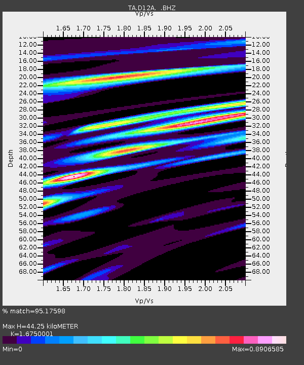
| Estimated Moho Depth: |
44.25 km |
| Estimated Crust Vp/Vs: |
1.68 |
| Assumed Crust Vp: |
6.622 km/s |
| Estimated Crust Vs: |
3.954 km/s |
| Estimated Crust Poisson's Ratio: |
0.22 |
|
| Radial Match: |
95.17598 % |
| Radial Bump: |
400 |
| Transverse Match: |
92.79622 % |
| Transverse Bump: |
400 |
| SOD ConfigId: |
2504 |
| Insert Time: |
2010-03-06 23:55:41.413 +0000 |
| GWidth: |
2.5 |
| Max Bumps: |
400 |
| Tol: |
0.001 |
|
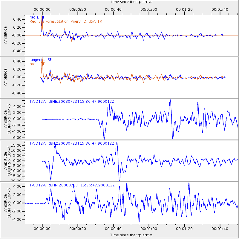
Signal To Noise
| Channel | StoN | STA | LTA |
| TA:D12A: :BHZ:20080723T15:36:47.900012Z | 49.301975 | 6.0151665E-6 | 1.220066E-7 |
| TA:D12A: :BHN:20080723T15:36:47.900012Z | 14.373329 | 1.1046816E-6 | 7.6856345E-8 |
| TA:D12A: :BHE:20080723T15:36:47.900012Z | 16.757843 | 1.9298257E-6 | 1.1515955E-7 |
| Arrivals |
| Ps | 4.7 SECOND |
| PpPs | 17 SECOND |
| PsPs/PpSs | 22 SECOND |


