You are here: Home > Network List > TA - USArray Transportable Network (new EarthScope stations) Stations List
> Station D12A Red Ives Forest Station, Avery, ID, USA > Earthquake Result Viewer
D12A Red Ives Forest Station, Avery, ID, USA - Earthquake Result Viewer
| Earthquake location: |
Lake Baykal Region, Russia |
| Earthquake latitude/longitude: |
51.6/104.2 |
| Earthquake time(UTC): |
2008/08/27 (240) 01:35:32 GMT |
| Earthquake Depth: |
16 km |
| Earthquake Magnitude: |
5.8 MB, 6.2 MS, 6.2 MW, 6.2 MW |
| Earthquake Catalog/Contributor: |
WHDF/NEIC |
|
| Network: |
TA USArray Transportable Network (new EarthScope stations) |
| Station: |
D12A Red Ives Forest Station, Avery, ID, USA |
| Lat/Lon: |
47.05 N/115.35 W |
| Elevation: |
1135 m |
|
| Distance: |
76.0 deg |
| Az: |
26.634 deg |
| Baz: |
335.867 deg |
| Ray Param: |
0.051258966 |
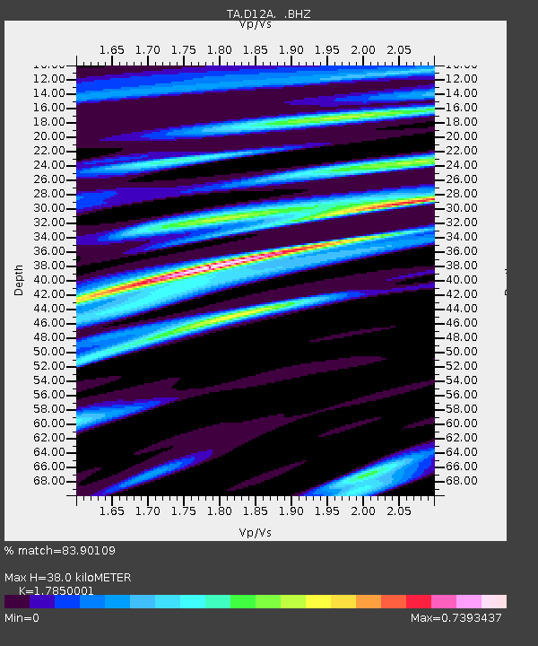
| Estimated Moho Depth: |
38.0 km |
| Estimated Crust Vp/Vs: |
1.79 |
| Assumed Crust Vp: |
6.622 km/s |
| Estimated Crust Vs: |
3.71 km/s |
| Estimated Crust Poisson's Ratio: |
0.27 |
|
| Radial Match: |
83.90109 % |
| Radial Bump: |
400 |
| Transverse Match: |
67.52119 % |
| Transverse Bump: |
400 |
| SOD ConfigId: |
2504 |
| Insert Time: |
2010-03-06 23:55:46.130 +0000 |
| GWidth: |
2.5 |
| Max Bumps: |
400 |
| Tol: |
0.001 |
|

Signal To Noise
| Channel | StoN | STA | LTA |
| TA:D12A: :BHZ:20080827T01:46:47.225012Z | 6.7638545 | 5.272791E-7 | 7.795542E-8 |
| TA:D12A: :BHN:20080827T01:46:47.225012Z | 2.556875 | 1.5605559E-7 | 6.103372E-8 |
| TA:D12A: :BHE:20080827T01:46:47.225012Z | 2.2387347 | 8.6801464E-8 | 3.877255E-8 |
| Arrivals |
| Ps | 4.7 SECOND |
| PpPs | 15 SECOND |
| PsPs/PpSs | 20 SECOND |


