You are here: Home > Network List > TA - USArray Transportable Network (new EarthScope stations) Stations List
> Station D12A Red Ives Forest Station, Avery, ID, USA > Earthquake Result Viewer
D12A Red Ives Forest Station, Avery, ID, USA - Earthquake Result Viewer
| Earthquake location: |
Vanuatu Islands |
| Earthquake latitude/longitude: |
-13.5/167.0 |
| Earthquake time(UTC): |
2008/09/08 (252) 18:52:06 GMT |
| Earthquake Depth: |
110 km |
| Earthquake Magnitude: |
6.4 MB, 6.9 MW, 6.9 MW |
| Earthquake Catalog/Contributor: |
WHDF/NEIC |
|
| Network: |
TA USArray Transportable Network (new EarthScope stations) |
| Station: |
D12A Red Ives Forest Station, Avery, ID, USA |
| Lat/Lon: |
47.05 N/115.35 W |
| Elevation: |
1135 m |
|
| Distance: |
91.6 deg |
| Az: |
41.934 deg |
| Baz: |
251.93 deg |
| Ray Param: |
0.04154369 |
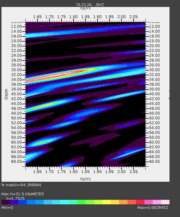
| Estimated Moho Depth: |
31.5 km |
| Estimated Crust Vp/Vs: |
1.75 |
| Assumed Crust Vp: |
6.622 km/s |
| Estimated Crust Vs: |
3.779 km/s |
| Estimated Crust Poisson's Ratio: |
0.26 |
|
| Radial Match: |
94.399864 % |
| Radial Bump: |
400 |
| Transverse Match: |
89.66405 % |
| Transverse Bump: |
400 |
| SOD ConfigId: |
2504 |
| Insert Time: |
2010-03-06 23:55:57.592 +0000 |
| GWidth: |
2.5 |
| Max Bumps: |
400 |
| Tol: |
0.001 |
|

Signal To Noise
| Channel | StoN | STA | LTA |
| TA:D12A: :BHZ:20080908T19:04:30.125029Z | 37.37754 | 4.2439765E-6 | 1.1354349E-7 |
| TA:D12A: :BHN:20080908T19:04:30.125029Z | 11.83618 | 7.1921346E-7 | 6.076399E-8 |
| TA:D12A: :BHE:20080908T19:04:30.125029Z | 16.216938 | 1.174216E-6 | 7.240676E-8 |
| Arrivals |
| Ps | 3.7 SECOND |
| PpPs | 13 SECOND |
| PsPs/PpSs | 16 SECOND |


