You are here: Home > Network List > TA - USArray Transportable Network (new EarthScope stations) Stations List
> Station D12A Red Ives Forest Station, Avery, ID, USA > Earthquake Result Viewer
D12A Red Ives Forest Station, Avery, ID, USA - Earthquake Result Viewer

| Earthquake location: |
Mariana Islands |
| Earthquake latitude/longitude: |
18.9/145.4 |
| Earthquake time(UTC): |
2007/10/31 (304) 03:30:17 GMT |
| Earthquake Depth: |
223 km |
| Earthquake Magnitude: |
6.2 MB, 7.2 MW, 7.2 MW |
| Earthquake Catalog/Contributor: |
WHDF/NEIC |
|
| Network: |
TA USArray Transportable Network (new EarthScope stations) |
| Station: |
D12A Red Ives Forest Station, Avery, ID, USA |
| Lat/Lon: |
47.05 N/115.35 W |
| Elevation: |
1135 m |
|
| Distance: |
82.5 deg |
| Az: |
42.893 deg |
| Baz: |
289.538 deg |
| Ray Param: |
0.04629288 |
| Estimated Moho Depth: |
28.25 km |
| Estimated Crust Vp/Vs: |
2.10 |
| Assumed Crust Vp: |
6.622 km/s |
| Estimated Crust Vs: |
3.157 km/s |
| Estimated Crust Poisson's Ratio: |
0.35 |
|
| Radial Match: |
91.8533 % |
| Radial Bump: |
400 |
| Transverse Match: |
85.30932 % |
| Transverse Bump: |
400 |
| SOD ConfigId: |
2564 |
| Insert Time: |
2010-03-06 23:56:26.421 +0000 |
| GWidth: |
2.5 |
| Max Bumps: |
400 |
| Tol: |
0.001 |
|
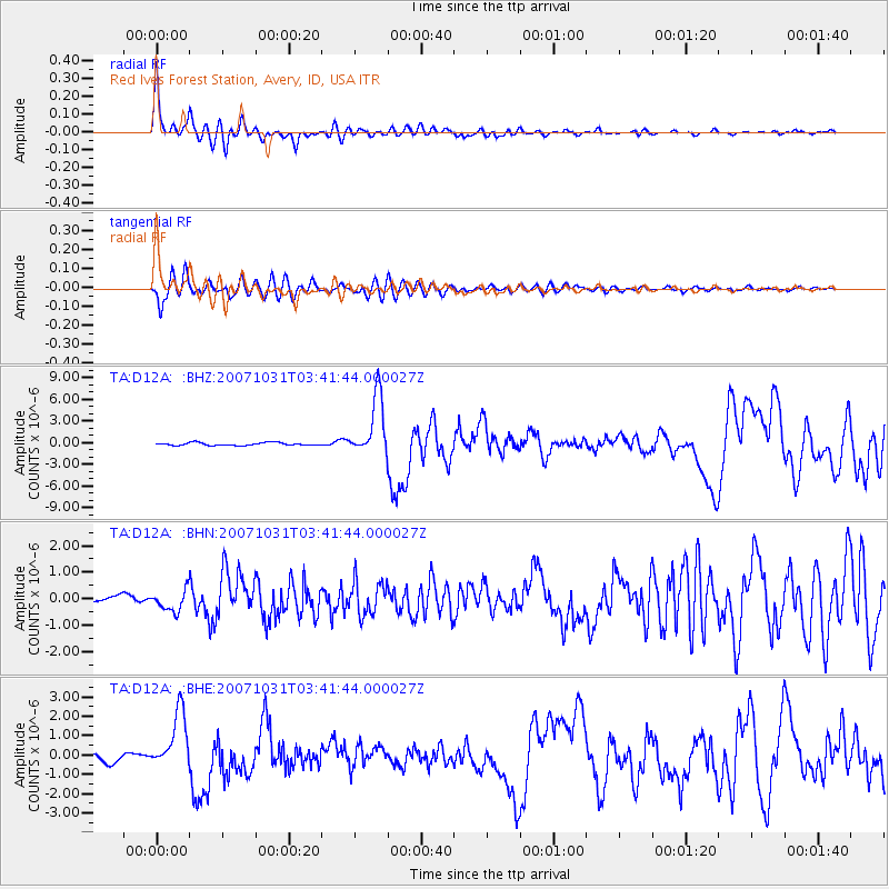
Signal To Noise
| Channel | StoN | STA | LTA |
| TA:D12A: :BHN:20071031T03:41:44.000027Z | 2.3635054 | 3.895726E-7 | 1.6482831E-7 |
| TA:D12A: :BHE:20071031T03:41:44.000027Z | 8.1044 | 1.499446E-6 | 1.850163E-7 |
| TA:D12A: :BHZ:20071031T03:41:44.000027Z | 22.161106 | 4.1609514E-6 | 1.877592E-7 |
| Arrivals |
| Ps | 4.8 SECOND |
| PpPs | 13 SECOND |
| PsPs/PpSs | 18 SECOND |


