You are here: Home > Network List > TA - USArray Transportable Network (new EarthScope stations) Stations List
> Station D12A Red Ives Forest Station, Avery, ID, USA > Earthquake Result Viewer
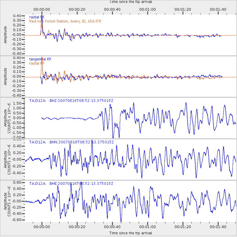
D12A Red Ives Forest Station, Avery, ID, USA - Earthquake Result Viewer

| Earthquake location: |
Solomon Islands |
| Earthquake latitude/longitude: |
-9.8/159.5 |
| Earthquake time(UTC): |
2007/08/16 (228) 08:39:27 GMT |
| Earthquake Depth: |
10 km |
| Earthquake Magnitude: |
6.1 MB, 6.7 MS, 6.4 MW |
| Earthquake Catalog/Contributor: |
WHDF/NEIC |
|
| Network: |
TA USArray Transportable Network (new EarthScope stations) |
| Station: |
D12A Red Ives Forest Station, Avery, ID, USA |
| Lat/Lon: |
47.05 N/115.35 W |
| Elevation: |
1135 m |
|
| Distance: |
93.9 deg |
| Az: |
43.07 deg |
| Baz: |
259.817 deg |
| Ray Param: |
0.04117892 |
| Estimated Moho Depth: |
33.0 km |
| Estimated Crust Vp/Vs: |
1.67 |
| Assumed Crust Vp: |
6.622 km/s |
| Estimated Crust Vs: |
3.971 km/s |
| Estimated Crust Poisson's Ratio: |
0.22 |
|
| Radial Match: |
93.72038 % |
| Radial Bump: |
400 |
| Transverse Match: |
85.31906 % |
| Transverse Bump: |
400 |
| SOD ConfigId: |
2564 |
| Insert Time: |
2010-03-06 23:56:39.392 +0000 |
| GWidth: |
2.5 |
| Max Bumps: |
400 |
| Tol: |
0.001 |
|
Signal To Noise
| Channel | StoN | STA | LTA |
| TA:D12A: :BHN:20070816T08:52:13.375015Z | 1.0914748 | 7.502489E-8 | 6.873717E-8 |
| TA:D12A: :BHE:20070816T08:52:13.375015Z | 3.00886 | 1.2531743E-7 | 4.1649468E-8 |
| TA:D12A: :BHZ:20070816T08:52:13.375015Z | 5.205468 | 2.8806937E-7 | 5.5339765E-8 |
| Arrivals |
| Ps | 3.4 SECOND |
| PpPs | 13 SECOND |
| PsPs/PpSs | 16 SECOND |


